Preview




Description
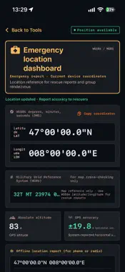
Find your bearing, mark your campsite, and keep a record of your route. Hiking Compass brings together a compass, GPS track recorder, waypoint guidance, and outdoor instruments for hiking, camping, trekking, and field observations. COMPASS & BEARING LOCK View your heading, switch between true and magnetic north, and lock a target bearing. See how far to turn, along with heading accuracy and sensor status to help assess the current reading. GPS TRACK RECORDING & BACKTRACK Record your route, elapsed time, distance, and accumulated ascent. Pause and save recordings, review previous tracks, and use your recorded path to help retrace your steps. Export tracks as GPX files for backup and sharing. WAYPOINTS & COORDINATES Mark campsites, parked vehicles, trailheads, and other important locations. View the bearing and straight-line distance to a waypoint. Enter and view coordinates in decimal degrees, DMS, UTM, and MGRS formats. ALTITUDE & OUTDOOR INSTRUMENTS Check positioning altitude, system-reported location accuracy, and available barometric pressure, pitch, and roll readings. View calculated sunrise, sunset, twilight, and moon phase information to help plan your time outdoors. CAMERA SIGHT & OBSERVATION RECORDS Use the camera view to check your sight bearing and tilt. Capture observation photos and save the observer's position and bearing for later review and sharing. LOCATION SHARING View your current position in multiple coordinate formats and copy location information for group rendezvous or verbal reporting. OFFLINE USE The compass, track recording, and saved on-device tracks can be used without an internet connection. Map backgrounds require network access. This version does not offer downloadable offline map backgrounds. Includes English and Chinese, in-app language selection, and a night vision mode. Heading and positioning readings depend on your device, permissions, and surroundings. Waypoint guidance shows direction and straight-line distance, not a verified passable route. Always consider the terrain when navigating outdoors. Feedback & support: [email protected]
What's New
Version 1.1 2026-11-14
What's New in v1.1: • Added spatial AR waypoint overlay and live solar arc projection inside Camera Sight. • Added Live Activities & Dynamic Island support for ...What's New in v1.1: • Added spatial AR waypoint overlay and live solar arc projection inside Camera Sight. • Added Live Activities & Dynamic Island support for active heading lock, waypoint guidance, and track recording. • Added offline NOAA Sun, Moon & Twilight calculations and an emergency WGS84 / MGRS Coordinate Dashboard. • Added 630nm Night Vision mode, One-Time Pro Unlock, and in-app Customer Support with MacID diagnostics. • Improved responsive landscape & foldable layouts along with stability enhancements. Technical Analysis
Package Overview Basic metadata
Bundle ID
com.fieldcompass.iosapp Current Version 1.1
Minimum iOS 17.0
Package Size App Store Size
Package Metadata 0 / 0 version records
Detailed binary, privacy manifest, framework, and Info.plist results have not been indexed for this package yet. The verified App Store and archive metadata above remains available.
Known Version Records
0 version records with stored package metadata
Stored metadata does not guarantee a package is currently available to download.
| Details | Version / IDs | Version date | Action |
|---|