
Preview


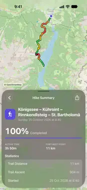

Description
Record your hikes, plan your own trails and use your maps offline, on iPhone and Apple Watch. No sign-up, no ads, no tracking: your hikes sync only through your own iCloud. And OpenHikes is open source, so anyone can check what it does. RECORD EVERY HIKE Tap record and put your phone away. OpenHikes records with the screen off, uses the barometer for accurate elevation and recovers your recording if the app closes. Control it with Siri, Control Center, the Live Activity or your Apple Watch. PLAN YOUR OWN TRAILS Add stops on the map or search for places. Your route follows mapped paths, so you know the real distance before you go. See springs, huts and viewpoints along the way, then save the trail and follow it. MAPS THAT WORK OFFLINE OpenStreetMap is the default and always free. Areas you have viewed are saved automatically and still work offline. Color your route by difficulty or steepness. FIND NEW TRAILS Browse hikes other people have shared nearby, and signposted routes from OpenStreetMap. Save one and follow it like your own. Sharing yours is free, and a person reviews every hike before it is published. PHOTOS AND PLACES Photos are pinned where you took them. Mark viewpoints, summits, water and shelters along a trail. After a hike, share it as an image with your photo, route and stats. GPX IN, GPX OUT Open GPX files from Files, Mail or AirDrop, with statistics and an interactive elevation profile. Export a hike as GPX, or as a ZIP file with its photos. ON YOUR WRIST AND LOCK SCREEN • Apple Watch: follow a trail or record a hike, even with your iPhone out of range • Home Screen and Lock Screen widgets with your trail and progress • A Live Activity on the Lock Screen and in the Dynamic Island ALSO INCLUDED • Apple Weather: hourly and 7-day forecasts, sunset times and severe weather warnings • A warning when you leave the trail or may finish after dark • Yearly totals, with your longest, highest and steepest hikes • Hikes saved to the Health app as workouts (optional) PRIVATE BY DESIGN Photos and offline maps stay on your device. Nothing is published unless you choose to share it. The full source code is on GitHub, under the MIT license. OPENHIKES PRO Everything above is free. Pro adds: • Stadia Outdoors and Stamen Terrain: hillshaded maps you can download for a whole route • Thunderforest Outdoors: a high-contrast map that stays readable in sunlight • Elevation where there is none: the climb, elevation profile and steepness colors for trails you draw, OpenStreetMap routes and GPX files without elevation These services charge OpenHikes for each use. Your subscription pays for them and keeps OpenStreetMap free. Monthly, with a one-week free trial and Family Sharing. Payment is charged to your Apple Account at confirmation of purchase. The subscription renews automatically unless canceled at least 24 hours before the end of the current period. Manage it in your Apple Account settings. Terms of Use (EULA): https://www.apple.com/legal/internet-services/itunes/dev/stdeula/ Privacy Policy: https://zsomborrajki.github.io/OpenHikes/privacy/
What's New
Version 1.4.4 2026-11-12
Now in Italian All of OpenHikes is now in Italian: the app, the widgets, the Live Activity, the Apple Watch app, Siri, and the privacy policy, terms and support...Now in Italian All of OpenHikes is now in Italian: the app, the widgets, the Live Activity, the Apple Watch app, Siri, and the privacy policy, terms and support page. The app uses your device’s language. Mountains in 3D Tilt the map and OpenStreetMap, Stadia Outdoors, Stamen Terrain and Thunderforest Outdoors now drape over the mountains in 3D, as Apple Satellite already did. Laid flat, the map looks just as before. Fixes • Going back no longer resets a screen as it slides away • Turning your phone no longer reloads a shared hike you’re previewing • Scrolling or tapping quickly no longer leaves the previous photo or address on screen • On routes with a pause, your position on the widget and the Lock Screen, and photos added from your library, now appear in the right spot • Places from OpenStreetMap no longer show up twice • A hike’s route no longer disappears from the map after a rare loading error Technical Analysis
Package Overview Basic metadata
Bundle ID
tappium.com.OpenHikes Current Version 1.4.4
Minimum iOS 18.4
Package Size App Store Size
Package Metadata 0 / 0 version records
Detailed binary, privacy manifest, framework, and Info.plist results have not been indexed for this package yet. The verified App Store and archive metadata above remains available.
Developer Information
Known Version Records
0 version records with stored package metadata
Stored metadata does not guarantee a package is currently available to download.
| Details | Version / IDs | Version date | Action |
|---|