
Preview


Description
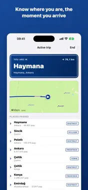
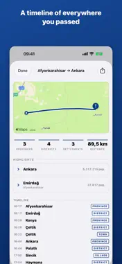
Waymark is a quiet travel companion for intercity drives. The moment you cross into a new province, district or town, it tells you where you are — the name, the population, and a short note on why the place matters — right on your lock screen. FULLY OFFLINE Boundary detection, place data and history all work with no signal. Waymark is most useful exactly where the network isn't: mountain passes, empty highways, the long gap between two cities. Nothing to download mid-trip. YOUR LOCATION STAYS ON YOUR DEVICE No account. No sign-up. No server. No third-party location or analytics SDK. Your location is used only on your iPhone to figure out which administrative area you're in, and it is never uploaded — there is nowhere for it to go. NOTIFICATION-LIGHT BY DESIGN By default you get a handful of alerts per trip — roughly one per province — not forty. If you want more detail, switch the sensitivity to districts or towns in Settings. Quiet hours and a per-place cooldown keep it from ever nagging. LIVE ACTIVITY FIRST The current place, the administrative hierarchy and your running count live on the lock screen and in the Dynamic Island. Glance, don't unlock. TRIP HISTORY & ROUTE MAP Every trip is saved on device with a route line and a timeline of everywhere you passed, biggest and smallest places highlighted. Share a trip as an image with the start and end automatically trimmed, so your home and destination aren't in the picture. COVERAGE Version 1 covers Turkey: all 81 provinces, 970 districts and about 44,000 villages and towns, with population figures and short encyclopaedia summaries for provinces and districts. Data sources: OpenStreetMap (ODbL), Wikidata & Wikipedia (CC BY-SA). Maps by Apple.
What's New
Version 1.1 2026-09-14
- Trip summaries now show start/end times and your average speed — overall and for each place along the way. - The shareable trip image is sharper, and now mark...- Trip summaries now show start/end times and your average speed — overall and for each place along the way. - The shareable trip image is sharper, and now marks your route's start and end. - Live Activity updates immediately when you cross into a new district or province. - Fixed a bug where a recovered trip could show a 0-minute duration. Technical Analysis
Package Overview Basic metadata
Bundle ID
tr.com.yakupad.waymark Current Version 1.1
Minimum iOS 26.0
Package Size App Store Size
Package Metadata 0 / 0 version records
Detailed binary, privacy manifest, framework, and Info.plist results have not been indexed for this package yet. The verified App Store and archive metadata above remains available.
Developer Information
Known Version Records
0 version records with stored package metadata
Stored metadata does not guarantee a package is currently available to download.
| Details | Version / IDs | Version date | Action |
|---|