
Preview




Description
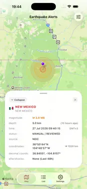
Earthquake Alerts: Live Map is a real-time earthquake tracker and seismic monitoring app that delivers global earthquake notifications, interactive fault line maps, and active volcano tracking directly to your iPhone and iPad. Designed for speed, clarity, and reliability, Earthquake Alerts: Live Map aggregates live seismic data from 10 international and regional seismological agencies so you can monitor tremors near your location or across the world. CORE FEATURES Live Earthquake Map and Heatmap Track recent earthquakes worldwide on an interactive map. Visualize seismic density with the heatmap layer, inspect tectonic plate boundaries, and view active fault lines. Custom Push Notifications and Smart Exclusions Receive instant earthquake alerts tailored to your preferences. Filter notifications by minimum magnitude, distance radius from your location, or specific countries. Use Smart Notification Exclusions to mute non-threatening offshore earthquakes at sea or deep-focus tremors, and schedule Quiet Hours for uninterrupted sleep. Multi-Territory and Home Country Monitoring Follow seismic activity in up to 4 countries or territories simultaneously, or use the one-tap Home Country filter to focus on tremors in your region. Detailed Seismic Event Data and Felt Reports Tap any event on Earthquake Alerts: Live Map to view exact epicenter coordinates, magnitude, depth in kilometers, distance from your location, and tsunami advisory flags. Submit and view community Felt Reports when you experience shaking. Active Volcano Tracker Monitor active and erupting volcanoes worldwide along the Pacific Ring of Fire and major fault zones, complete with elevation, rock type, and eruption status details. Seismic Analytics and 30-Day Reports Analyze seismic trends over 24-hour, 7-day, and 30-day periods with magnitude distribution charts, depth breakdowns, and regional activity summaries. iOS Quick Actions and Siri Shortcuts Access the latest earthquake list or jump straight to the live seismic map from your Home Screen icon or with Siri voice shortcuts. TRUSTED SEISMOLOGICAL DATA SOURCES Earthquake Alerts: Live Map combines public real-time feeds from 10 seismological institutions: - United States Geological Survey (USGS) - European-Mediterranean Seismological Centre (EMSC) - Disaster and Emergency Management Authority of Turkey (AFAD) - Bogazici University Kandilli Observatory and Earthquake Research Institute (KOERI) - GFZ German Research Centre for Geosciences (GFZ) - GeoNet New Zealand (GNS Science) - Japan Meteorological Agency (JMA) - National Institute of Geophysics and Volcanology of Italy (INGV) - National Seismological Center of Chile (CSN) - National Seismological Service of Mexico (SSN) - National Oceanic and Atmospheric Administration (NOAA) for tsunami risk indicators TRANSPARENCY AND PRIVACY Earthquake Alerts: Live Map is an independent seismic monitoring tool and is not affiliated with any government agency. No user account is required, and location permissions are strictly optional for distance-based alerts. Privacy Policy: https://doc-hosting.flycricket.io/earthquake-alerts-privacy-policy/3b86da3c-243d-4162-999f-178a398bebd4/privacy Terms of Use: https://www.apple.com/legal/internet-services/itunes/dev/stdeula/
What's New
Version 3.0.0 2026-11-09
This version of Earthquake Alerts: Live Map introduces multi-territory earthquake filtering for up to 4 regions, smart notification exclusion rules for offshore...This version of Earthquake Alerts: Live Map introduces multi-territory earthquake filtering for up to 4 regions, smart notification exclusion rules for offshore and deep tremors, Home Country quick filtering, iOS Quick Actions, Siri Shortcuts, an in-app FAQ guide, and improved AFAD and Kandilli data reliability. Technical Analysis
Package Overview Basic metadata
Bundle ID
com.earthquaketracker.seismicalerts.map Current Version 3.0.0
Minimum iOS 17.0
Package Size App Store Size
Package Metadata 0 / 0 version records
Detailed binary, privacy manifest, framework, and Info.plist results have not been indexed for this package yet. The verified App Store and archive metadata above remains available.
Known Version Records
0 version records with stored package metadata
Stored metadata does not guarantee a package is currently available to download.
| Details | Version / IDs | Version date | Action |
|---|