Preview


Description
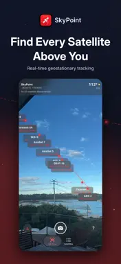
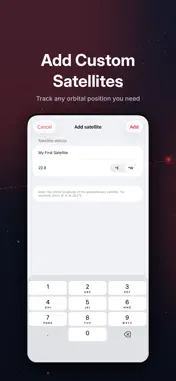
SkyPoint — AR Satellite Finder Point your phone at the sky and instantly see where geostationary satellites are. SkyPoint uses augmented reality to overlay satellite positions directly on your camera feed, showing you exactly where to aim a satellite dish. How it works Open the app, point your phone upward, and SkyPoint displays satellite labels pinned to their real positions in the sky. Each label shows the satellite name, orbital position, elevation angle, and compass bearing. A dashed arc traces the Clarke Belt — the geostationary orbit 35,786 km above the equator where all the satellites sit. As you pan your phone around, the labels stay locked in place with smooth, stable tracking. Built for professionals SkyPoint was designed for broadcast engineers and technical producers who need to locate satellites during site surveys. Whether you're aligning an uplink dish for a live sports broadcast or checking line-of-sight at a new venue, SkyPoint gets you pointed in the right direction before you even unpack your equipment. • Real-time AR overlay with rock-solid label tracking • Compass heading, GPS coordinates, and elevation data on screen • Geotagged screenshots that capture the AR view with all satellite labels • Compass confidence indicator showing how reliable your heading data is • One-tap north recalibration when you move to a new location 70+ satellites worldwide The built-in database covers major geostationary satellites across every region: • Europe: Astra 2E/2F/2G, Hot Bird, Eutelsat series • Middle East: Arabsat, Türksat, Badr • Asia Pacific: AsiaSat, Thaicom, Measat, Palapa, Koreasat, JCSAT • Australia: Optus D1/D2/D3, Sky Muster, Kacific-1 • Americas: SES, Intelsat, Galaxy, Hispasat, Amazonas Satellites are organised by operator so you can quickly find what you need. Filter by all satellites, those above the horizon, or only the ones you've selected. Toggle individual satellites on or off to keep the AR view clean. Add your own satellites Need a satellite that isn't in the database? Add custom satellites by entering a name and orbital longitude. Your custom satellites appear alongside the built-in ones with full AR overlay support. Smart compass handling Getting an accurate heading from a phone compass is hard — magnetic interference from buildings, vehicles, and metal structures can throw it off. SkyPoint uses a hybrid approach: ARKit's gyroscope provides smooth, jitter-free tracking frame to frame, while the compass gently corrects for long-term drift. The result is labels that stay perfectly stable as you move the phone, with none of the wobble you get from raw compass data. If the compass accuracy drops, SkyPoint warns you and suggests recalibration. You can recalibrate from the compass with a single tap, or long-press to manually set north by pointing your phone in a known direction. Capture and share Take geotagged screenshots that include satellite labels, the Clarke Belt arc, and your compass heading. Photos are saved with GPS metadata so you can review survey locations later. A subtle watermark marks each capture as created with SkyPoint. Labels that stay readable When satellites cluster at similar orbital positions, labels alternate above and below the Clarke Belt arc so they don't overlap. Labels also rotate to stay readable when you tilt your phone to landscape orientation. No internet required All satellite position calculations run on-device using standard orbital mechanics. SkyPoint works anywhere — no network connection needed. Requirements • iPhone with ARKit support (iPhone 12 or later recommended) • iOS 16 or later • Camera and location permissions
What's New
Version 1.2.2 2026-06-13
Bug fixed where satellite placements could potentially be vertically flipped. Technical Analysis
Package Overview Basic metadata
Bundle ID
timgoff.SkyPoint Current Version 1.2.2
Minimum iOS 16.6
Package Size App Store Size
Package Metadata 1 / 3 version records
Detailed binary, privacy manifest, framework, and Info.plist results have not been indexed for this package yet. The verified App Store and archive metadata above remains available.
Known Version Records
1 version record with stored package metadata • 3 known version records
Stored metadata does not guarantee a package is currently available to download.
| Details | Version / IDs | Version date | Action |
|---|---|---|---|
| 1.93 MB | v1.2.2 App Store ID: 886928704Build: 1.2.2 | 2026-06-13 23:30:51 | Get Version |
| Not archived | v1.2.1 App Store ID: 885414623Build: 1.2.1 | 2026-05-08 21:48:26 | Request Version |
| Not archived | v1.2 App Store ID: 885201311Build: 1.2 | 2026-05-07 00:18:22 | Request Version |