
Preview


Description
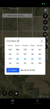
LLD Map: Navigate Canadian Land with Confidence—Anywhere, Anytime LLD Map is your essential companion for exploring and navigating land in Canada, even when you’re off the grid. Whether you’re a landowner, surveyor, outdoor enthusiast, or simply exploring new territories, LLD Map ensures you always know where you are and how to get where you’re going. Reliable Navigation—Even Offline Never worry about losing your way when cell service drops. With LLD Map, you can initiate turn-by-turn navigation before heading into areas with limited connectivity. Your directions will continue to work seamlessly, so you can focus on your journey without the fear of getting stranded halfway to your destination. Key Features: Find Land by LLD: Effortlessly search and locate land parcels across Canada using the Legal Land Description (LLD) system. Turn-by-Turn Directions: Get clear, step-by-step navigation to your chosen destination, ensuring you always stay on track. Offline Map Integration: Enjoy seamless navigation with both Apple and Google maps, even in remote areas with little or no cell coverage. Multiple Map Views: Easily switch between Topographical, 3D Satellite, 2D Satellite, Dark Roads, and Light Roads to suit your needs and preferences. Keep Track of Your Journey: Location History: Access a detailed history of all the locations you’ve viewed, complete with the date you accessed them—perfect for retracing your steps or planning future trips. Favorites: Mark any land parcel as a favorite for quick access later. Personal Notes: Add custom notes to any land, helping you remember important details or observations. Whether you’re planning your next adventure, managing land, or simply exploring the great Canadian outdoors, LLD Map gives you the tools and confidence to navigate with ease—no matter where the road (or trail) takes you. Download LLD Map today and explore Canada like never before!
What's New
Version 1.0.132 2026-09-06
September 5, 2026 Finding rural locations and managing drone missions is now faster, smarter, and easier. Instantly identify your Legal Land Description (LLD) b...September 5, 2026 Finding rural locations and managing drone missions is now faster, smarter, and easier. Instantly identify your Legal Land Description (LLD) by taking a photo, search and download KMZ drone mission files for online or offline use, and automatically track your LLD search and flight history by date. We've also streamlined login and enhanced overall performance, reliability, and stability Technical Analysis
Package Overview Basic metadata
Bundle ID
ai.sga.lld Current Version 1.0.132
Minimum iOS 15.0
Package Size App Store Size
Package Metadata 0 / 2 version records
Detailed binary, privacy manifest, framework, and Info.plist results have not been indexed for this package yet. The verified App Store and archive metadata above remains available.
Developer Information
Known Version Records
0 version records with stored package metadata • 2 known version records
Stored metadata does not guarantee a package is currently available to download.
| Details | Version / IDs | Version date | Action |
|---|---|---|---|
| Not archived | App Store ID: 877856513 | Unknown | Request Version |
| Not archived | App Store ID: 877526949 | Unknown | Request Version |