
Preview







Description
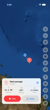
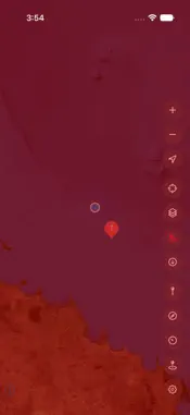
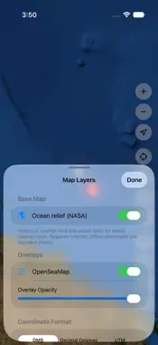
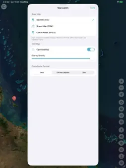
ReefMap is offline-first marine navigation for boaters, fishers, divers, and reef explorers. Download your waters once and navigate with no signal — nautical charts, GPS, and the safety tools you actually need — free forever. WORKS OFFLINE Save an OpenStreetMap and OpenSeaMap region for use miles offshore — charts, your GPS position, waypoints, tracks, and routes. No cell signal required. Satellite imagery and Ocean relief require internet and are not included in offline downloads. CHARTS & POSITION • Satellite imagery from Esri as the default view (requires internet), or switch to the OpenStreetMap chart • OpenSeaMap nautical seamarks layered on top, with an opacity slider • Optional Ocean relief (NASA): satellite-derived land imagery and shaded seafloor relief from August 2004 for regional overviews. Requires internet; limited detail, without depth queries or detailed reef and fishing layers • Live GPS position, speed over ground, and course • Coordinates always on screen — DMS, decimal degrees, or UTM; tap to copy • Full-screen digital compass with true and magnetic heading PLAN & NAVIGATE • Drop waypoints with marine icons and categories — reefs, wrecks, anchorages, fishing marks, harbors • Record GPS tracks and replay your route home • Build multi-leg routes, or draw one on the chart with your finger, and follow it with live cross-track error and arrival alerts • Trip computer: SOG, COG, VMG, trip distance and time, plus a barometric-pressure trend for weather awareness • Tide predictions for US waters — highs, lows, and the current level from the nearest NOAA station SAFETY — ALWAYS FREE • Anchor alarm — set a swing radius and get alerted if you drag, even with the screen off • Man Overboard (MOB) — one tap drops a mark and switches to bearing-and-distance back to the spot • Night mode — a red-light helm palette that protects your night vision • Keep-screen-awake while you navigate YOUR DATA, YOUR DEVICE • Export waypoints and tracks as GPX • Everything is stored on your device • Built for iPhone and iPad FREE CORE, OPTIONAL PRO Most chart apps cost $50–$150 every year. In ReefMap every safety tool is free forever — anchor alarm, Man Overboard, night mode, GPS, compass, waypoints, tracks and routes — and your first offline region is free too. ReefMap Pro is an optional upgrade that adds unlimited offline map downloads plus anchor-watch history and named anchorages. Choose Annual ($19.99 a year, with a 2-week free trial for new subscribers), Monthly ($3.99 a month), or a one-time Lifetime purchase ($49.99). Subscriptions renew until cancelled; manage or cancel anytime in your Apple Account settings. Lifetime covers every Pro feature that runs on your device, forever; future live data, such as worldwide tides and weather, will need a subscription. It's built on free public marine data (OpenStreetMap, OpenSeaMap), so there are no recurring chart-license fees to pass on to you. ON THE WAY Tides outside US waters, depth contours, reef-health overlays, and live weather are in development. The safety core always stays free. — ReefMap is intended as a navigation aid only. It should not be used as a primary means of navigation. Always carry and use official nautical charts and maintain a proper lookout. Map data is derived from public sources and may be incomplete or inaccurate. Terms of Use: https://www.apple.com/legal/internet-services/itunes/dev/stdeula/ Privacy Policy: https://reefmap.stevcodes.com/privacy
Technical Analysis
Package Overview Basic metadata
Bundle ID
com.stevcodes.reefmap Current Version 1.0.0
Minimum iOS 17.2
Package Size App Store Size
Package Metadata 0 / 0 version records
Detailed binary, privacy manifest, framework, and Info.plist results have not been indexed for this package yet. The verified App Store and archive metadata above remains available.
Developer Information
Known Version Records
0 version records with stored package metadata
Stored metadata does not guarantee a package is currently available to download.
| Details | Version / IDs | Version date | Action |
|---|