
Preview








Description
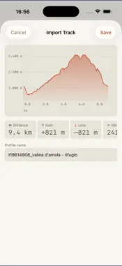
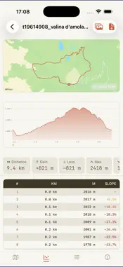
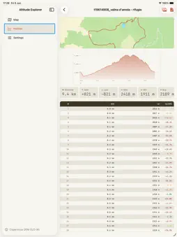
Altitude Explorer Explore the terrain beneath your routes with precise elevation data powered by the Copernicus DEM GLO-90 — a global Digital Elevation Model derived from TanDEM-X radar imagery, operated by DLR and Airbus Defence and Space under the European Union's Copernicus Programme. Global coverage of all land areas (approximately 90S to 84N latitude, 180W to 180E longitude). What you can do • Point query — tap anywhere on the map to get the exact elevation at that location • Line profile — place two markers and instantly generate a cross-section of the terrain between them • Road profile — follow a real driving or walking route and see how elevation changes along the way • Track import — load GPX, KML, KMZ, or GeoJSON files and visualise the elevation of your own tracks • Interactive chart — drag a scrubber along the profile chart to read elevation and distance at any point • Saved profiles — store your profiles in a personal library and revisit them anytime • PDF export — export any profile as a PDF with map snapshot, chart, stats and full data table Data & accuracy The dataset is hosted on proprietary servers for fast, direct access across all supported regions. Accuracy varies with terrain complexity — dense vegetation, steep slopes, and urban areas may introduce artefacts. Full attribution and the Copernicus Data Policy are available directly within the app under Settings → About. Customisation Choose your units (km/miles, m/ft), map style, interpolation algorithm, chart colour and line weight. Available in English, Italian, French, German and Spanish.
Technical Analysis
Package Overview Basic metadata
Bundle ID
com.sramp.altitudeexplorer Current Version 1.0
Minimum iOS 17.0
Package Size App Store Size
Package Metadata 0 / 1 version records
Detailed binary, privacy manifest, framework, and Info.plist results have not been indexed for this package yet. The verified App Store and archive metadata above remains available.
Developer Information
Known Version Records
0 version records with stored package metadata • 1 known version records
Stored metadata does not guarantee a package is currently available to download.
| Details | Version / IDs | Version date | Action |
|---|---|---|---|
| Not archived | App Store ID: 883313198 | Unknown | Paid / Arcade |