Preview


Description
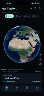
Explore source-linked reports about earthquakes, storms, fires and other natural events on an interactive 3D globe. The app brings public reports from the U.S. Geological Survey, NASA EONET and GDACS together with source times, event details and links to the original reports. • Explore event markers on a globe using NASA's historical Blue Marble imagery, with a bundled map fallback when imagery cannot load. • Filter recent reports by event type and time window, then inspect available measurements and the reporting source. • Browse article headlines indexed by GDELT when available; full stories open on the original publisher's website. If the index is unavailable, clearly labelled official event reports remain accessible. • Save reports, stories and places on your iPhone. Your last stored reports remain available offline. • Open selected international broadcasters' official pages from the Live TV tab. Playback and availability depend on each broadcaster. The global map is a historical mosaic, not a live satellite view. Headline markers show approximate regions mentioned in a story, not verified incident positions. This is an independent information app, not an emergency alert service. For current warnings and safety instructions, follow local authorities and emergency services.
Technical Analysis
Package Overview Basic metadata
Bundle ID
com.senolt.earthaster Current Version 1.0
Minimum iOS 18.0
Package Size App Store Size
Package Metadata 0 / 0 version records
Detailed binary, privacy manifest, framework, and Info.plist results have not been indexed for this package yet. The verified App Store and archive metadata above remains available.
Developer Information
Known Version Records
0 version records with stored package metadata
Stored metadata does not guarantee a package is currently available to download.
| Details | Version / IDs | Version date | Action |
|---|