
Preview




Description
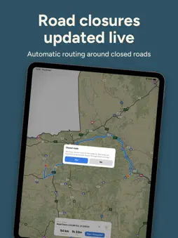
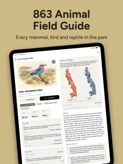
Turn-by-turn directions for Kruger National Park that work with no signal, no data and no roaming. The whole park is already on your phone. Plan a drive, see how long it will really take at bush speeds, and keep an eye on when your gate closes. When something crosses the road, the field guide helps you work out what it is. NAVIGATION Offline turn-by-turn navigation. Routes are worked out on your phone, stay inside the park and warn you about closed and restricted roads. Road closures are updated daily. Make the gate. Every entrance and camp gate shows its opening and closing times, month by month, with a countdown to the next change. Plan a drive. Start from one of 42 ready-made half-day and full-day drives from the main rest camps, or build your own with several stops and time at each. Pick a speed, or go by the speed limits, and the arrival time reflects how people really drive in the park: slowly, and stopping often. Share a drive. Send a saved drive as a link. If the other person has Kruger Nav, it opens straight in the app. Press and hold anywhere on the map to drive there, add it as a stop, save the spot or log a sighting. THE MAP Kruger mapped in more detail than any other map of the park: every road, river, camp, gate, picnic site, waterhole, bird hide and viewpoint, plus 54 heritage sites with their stories. Terrain shading shows the hills and valleys. Read the landscape. Overlay rainfall, river catchments, vegetation and geology, and tap any zone to learn what you're driving through. Where to look. Wildlife Density shades the roads by how often big game is seen along them. You can change the colours of the roads, rivers and camps, and save your own map styles. THE FIELD GUIDE 863 animals: mammals, birds, reptiles, frogs, fish and insects. Each has a picture, with details such as size, diet, habitat, how rare it is in Kruger and its conservation status. Many have names in Afrikaans, isiZulu, isiXhosa and other South African languages. For most birds, a map shows where in Kruger they've been recorded, in summer and in winter. The SA National Tree List: 1,625 trees, searchable by the number on the tree signs. Around 3,000 articles on Kruger's wildlife, plants and places, adapted from Wikipedia contributors (CC BY-SA 4.0) and readable with no signal. Three illustrated guides: animal spotting, sighting etiquette and the history of Kruger. YOUR SIGHTINGS Log a sighting from an animal's page or straight from the map. It saves the time and place and puts the animal on your map, and you can have its icon disappear after a few days. Your Sightings keeps a life list and a list for the trip you're on, and you can mark animals you've seen on earlier visits. AND ALSO - Search places, animals, roads, articles or coordinates (DD, DMS or DMM) - Find the nearest petrol station, picnic site or bird hide - Sunrise, sunset, moon phase and a five-day forecast - Choose what your dashboard shows: time, speed, gate times, sun or weather - What to expect at each entrance gate (paperwork, fees, the Wild Card) and the history of each camp - Keep your SANParks Wild Card details in the app and share them as a PDF - Road updates arrive over the air, with no app update needed - Works on iPhone, iPad and iPhone Duo, open or closed PRIVACY No account. No login. No tracking. No ads. Your saved places, routes and sightings stay on your devices. With iCloud sync on (you can turn it off), they're also kept in your own iCloud so your iPhone and iPad match. Nobody else sees any of it, me included. The app only goes online for road updates, the weather, iCloud sync and opening shared drive links. Kruger Nav is an independent app, built by one person who'd rather be watching the road for lions. It isn't affiliated with or endorsed by SANParks. Note: live location needs GPS. Every iPhone has it, but on iPad only cellular (SIM/eSIM) models do. A Wi-Fi-only iPad shows the map, not your position.
What's New
Version 7.0 2026-11-06
This is a big one for the field guide and for keeping track of what you see. NEW - Field guide – 863 animals: mammals, birds, reptiles, frogs, fish and insects... Technical Analysis
Package Overview Basic metadata
Bundle ID
Real-Lux-LTD.KrugerNavigator Current Version 7.0
Minimum iOS 17.6
Package Size App Store Size
Package Metadata 0 / 0 version records
Detailed binary, privacy manifest, framework, and Info.plist results have not been indexed for this package yet. The verified App Store and archive metadata above remains available.
Price History (USA store)
2 recorded price change points. These are historical observations, not a guarantee of the current price.
| Recorded at | Price | Currency |
|---|---|---|
| 1.99 | USD | |
| 4.99 | USD |
Developer Information
Known Version Records
0 version records with stored package metadata
Stored metadata does not guarantee a package is currently available to download.
| Details | Version / IDs | Version date | Action |
|---|