
Preview





Description
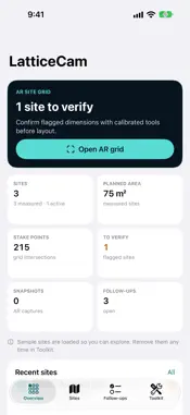
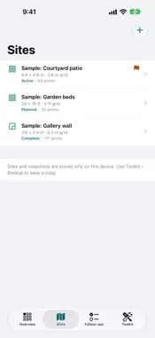
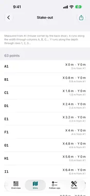
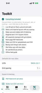
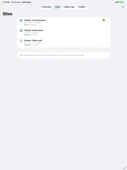
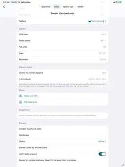
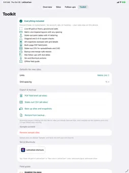
LatticeCam is a private AR site-grid planner. Lay out a patio, deck, garden beds, a slab, a tiled floor or a gallery wall: enter the size and spacing, get every stake point and square check, then see the same grid placed on the real surface. PLAN THE LAYOUT • Width, depth and grid spacing in metric or imperial units, converted in place • Every stake point lettered A1, B1, C1… with X, Y and distance from A1 • Grid lines, full cells, area and perimeter • Corner-to-corner diagonal and a 3-4-5 square check sized to your site • A plan diagram drawn from your numbers SEE IT ON SITE • Live ARKit grid on floors, ground or walls • The grid matches your site's real rectangle and spacing, with the A1 corner highlighted • Rotate in 15° steps, adjust line opacity, and tap again to move it • Capture snapshots stamped with the site, spacing, surface and time KEEP THE FIELD RECORD • Sites with status, "verify before layout" flags, A1 orientation notes and notes • Follow-ups with owners and due dates, linked to sites • An overview of measured area, stake points, sites to verify and overdue follow-ups SHARE AND BACK UP • Multi-page PDF field brief: a summary page plus one page per site with its plan, numbers and snapshots • Stake-out CSV for spreadsheets and CAD • A backup file that includes snapshots. Restore merges and never deletes your existing sites MORE • Siri and Shortcuts: "Open AR grid in LatticeCam" and "New site in LatticeCam" • Offline field guide for reliable AR layout • Dark mode, Dynamic Type and iPad layouts • Optional labeled sample sites to explore EVERYTHING INCLUDED One purchase, no subscription. No account, ads, tracking, analytics or developer server. Your sites and snapshots stay on your device unless you export them. LatticeCam is a visualization and planning aid, not a calibrated surveying instrument. AR placement and entered dimensions are estimates. Confirm critical dimensions, boundaries, grade, utilities and safety requirements with appropriate tools and qualified professionals. The live AR grid requires a device with ARKit.
What's New
Version 2.0 2026-10-30
LatticeCam 2.0 is a major upgrade. • Layout planner: enter width, depth and spacing in metric or imperial units to get every stake point (A1, B1…), the grid li...LatticeCam 2.0 is a major upgrade. • Layout planner: enter width, depth and spacing in metric or imperial units to get every stake point (A1, B1…), the grid lines, area, perimeter, the diagonal and a 3-4-5 square check, drawn as a plan. • Site-sized AR grid: place your site's real grid on a floor or wall, rotate it, adjust opacity, and capture snapshots stamped with the site, spacing and time. • Export: multi-page PDF field briefs and stake-out CSV files. • Backup and restore, including snapshots. Restoring merges and never deletes. • Siri and Shortcuts: "Open AR grid" and "New site". • Follow-ups linked to sites, and an overview built from your saved sites. • Redesigned interface with readable dark mode, larger text support and a proper iPad layout. • Your 1.0 records are migrated automatically. Technical Analysis
Package Overview Basic metadata
Bundle ID
com.realbobcorbin.LatticeCam Current Version 2.0
Minimum iOS 17.0
Package Size App Store Size
Package Metadata 0 / 0 version records
Detailed binary, privacy manifest, framework, and Info.plist results have not been indexed for this package yet. The verified App Store and archive metadata above remains available.
Price History (USA store)
5 recorded price change points. These are historical observations, not a guarantee of the current price.
| Recorded at | Price | Currency |
|---|---|---|
| 3.99 | USD | |
| 0.0 | USD | |
| 2.99 | USD | |
| 3.99 | USD | |
| 2.99 | USD |
Developer Information
Known Version Records
0 version records with stored package metadata
Stored metadata does not guarantee a package is currently available to download.
| Details | Version / IDs | Version date | Action |
|---|