
Preview



Description
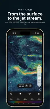
WindTrac shows the wind the way it actually moves, and with WindTrac Pro it keeps working when the signal is gone. Download the forecast for where you're heading and the live, animated map of wind, waves and weather goes with you: offshore, into the mountains or onto a plane. Instead of a grid of arrows or a table of numbers, tens of thousands of particles flow with the forecast wind, speed as colour, direction as motion. The gust front, the light-air hole and the wind bending around a headland are obvious at a glance. Built for kitesurfers, windsurfers and wing foilers, sailors and boaters, surfers, paraglider pilots and anglers. Anyone who plans the day around the wind and the water. What makes it different A forecast that works offline. Most weather apps go blank without a connection. With WindTrac Pro, pick an area and the layers you need, and every forecast hour comes with you, along with the timeline, the animation and the map itself. Keep several areas saved. Eight forecast models in one app. Switch between NOAA GFS, the NOAA GEFS ensemble mean, DWD ICON and the high-resolution ICON-EU, ECMWF IFS HRES and the ECMWF AIFS AI model, plus two wave models. When the models disagree, you see it straight away. Numbers where they matter. The strongest gusts, the calmest patches, the biggest waves and the warmest and coldest spots are labelled on the map automatically. Read the wind Tap anywhere for the exact speed in knots, km/h, mph or m/s, or switch to gusts to see what you will really be reefing, depowering or scrubbing a launch for. The altitude slider runs from 10 m up through 850, 700, 500 and 250 hPa, from a paraglider launch to the jet stream. Read the sea Significant wave height and direction, animated so you can watch a swell roll towards your beach, plus peak and mean wave period to tell a short, choppy wind sea from a long-period groundswell before you load the car. Heights in metres or feet. Plan the session, the passage or the flight Drag the timeline to any time in the forecast, or press play and watch a weather system cross the map in seconds. Rain, snow, low cloud and temperature (°C or °F) are a tap away. Save favourite spots and show times in your zone, the spot's or UTC. Storm Watch In the US and Canada, official watches and warnings from the National Weather Service and Environment Canada are drawn on the map. Tap one for the full text. Follow hurricanes with the National Hurricane Center's forecast cone, track and 34-knot wind field, which moves with the timeline so you can see when tropical-storm-force wind could arrive. All of it can be switched off. Free and Pro The live map, every layer and model, labels, playback, Storm Watch, five saved spots and the next 24 hours of forecast are free, with no ads and no account. WindTrac Pro is an optional subscription that adds offline maps, the full multi-day forecast and unlimited saved spots. Privacy Policy: https://windtrac.app/privacy WindTrac is a planning aid, not a substitute for official forecasts and warnings. It is an independent app, not affiliated with, endorsed by, or approved by NOAA, the US National Weather Service, the National Hurricane Center, Environment Canada, ECMWF, DWD, or any other agency whose public data it displays.
What's New
Version 1.4 2026-10-19
Temperature and gust labels: On the temperature and gust layers, readings now appear right across the map, just like wind speeds . Ready for iPhone Duo and iOS ... Technical Analysis
Package Overview Basic metadata
Bundle ID
com.rivolu.windtrac Current Version 1.4
Minimum iOS 18.0
Package Size App Store Size
Package Metadata 1 / 3 version records
Detailed binary, privacy manifest, framework, and Info.plist results have not been indexed for this package yet. The verified App Store and archive metadata above remains available.
Developer Information
Known Version Records
1 version record with stored package metadata • 3 known version records
Stored metadata does not guarantee a package is currently available to download.
| Details | Version / IDs | Version date | Action |
|---|---|---|---|
| 21.33 MB | v1.3 App Store ID: 888308975Build: 1.3 | 2026-08-10 08:02:38 | Get Version |
| Not archived | App Store ID: 886893199 | Unknown | Request Version |
| Not archived | App Store ID: 884938719 | Unknown | Request Version |