
Preview

Description
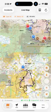
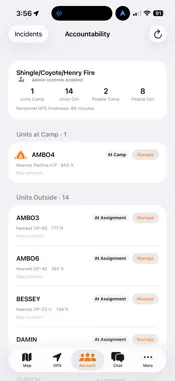
Wildfire EMS Tracker helps wildfire and emergency response teams coordinate personnel, build shared incident maps, and document progress in the field. Create an incident or join your team using a command link or QR code. Authorized contributors can draw map features, record walked lines with GPS, and update selected fire-edge sections as contained. INCIDENT MAPPING • Draw lines by hand or record them using GPS. • Map fire edges, handlines, dozer lines, roads used as control lines, and wet lines. • Distinguish planned work from completed lines. • Place Incident Command Post markers and other incident reference points. • Connect boundary segments and calculate estimated acreage. • Pan while drawing and undo the last stroke or point without clearing earlier work. TEAM COORDINATION • View shared incident maps and participating personnel. • Share incident join links and command QR codes. • Manage map-editing and GPS permissions separately for each incident. • Keep access and contributions organized by incident. FIELD WORK AND RECOVERY • Preserve local drafts and recorded GPS points during connection interruptions. • Retry pending uploads and review saves that need correction. • Export mapping work as GeoJSON. A department account or incident invitation is required. GPS features require location permission. An internet connection is needed to join incidents, load online map content, and synchronize shared updates.
What's New
Version 1.7.1 2026-11-20
• Create incidents and share command QR codes or join links from your phone. • Draw fire and control lines by hand or record a line using GPS. • Mark selected s...• Create incidents and share command QR codes or join links from your phone. • Draw fire and control lines by hand or record a line using GPS. • Mark selected sections of a fire edge as contained. • Pan the map while drawing and undo the last stroke or point without clearing your work. • Set separate map-editing and GPS permissions for each incident. • Connect boundary segments and calculate estimated acreage. • Updated wildfire line styles and Incident Command Post markers. • Improved syncing, pending-save messages, and recovery of unsaved work. Technical Analysis
Package Overview Basic metadata
Bundle ID
com.responderwebworks.wildfireemstracker Current Version 1.7.1
Minimum iOS 17.0
Package Size App Store Size
Package Metadata 0 / 0 version records
Detailed binary, privacy manifest, framework, and Info.plist results have not been indexed for this package yet. The verified App Store and archive metadata above remains available.
Known Version Records
0 version records with stored package metadata
Stored metadata does not guarantee a package is currently available to download.
| Details | Version / IDs | Version date | Action |
|---|