
Preview


Description
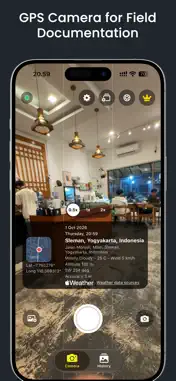
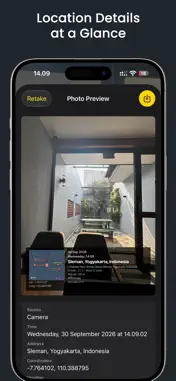
CamStamp helps you create clear and professional field documentation with location information printed directly on each photo. Capture a new image or choose photos from your library, then add a customizable GPS stamp. Each stamp can display the address, GPS coordinates, capture date and time, weather, temperature, altitude, compass direction, and GPS accuracy. Coordinates can be displayed in decimal or DMS format. Choose a stamp template, include a map, add a project or company name, and use your own logo. You can show only the information you need to keep every result easy to read. CamStamp includes zoom, flash, timer, front and rear camera support, and volume-button capture. You can also keep the original photo without a stamp. Existing photos can be selected from your library, and multiple images can be processed using Batch Stamp. Completed photos and their location details are saved in history. History data can be exported as CSV or KML for spreadsheets, Google Earth, and other compatible mapping tools. You can also enter latitude, longitude, and an address manually when a project requires a specific location. CamStamp is useful for field surveys, inspections, construction, property documentation, travel records, and other work that benefits from visible location evidence. Privacy Policy: https://ihwan.id/camstamp-privacy-policy.html
Technical Analysis
Package Overview Basic metadata
Bundle ID
id.ihwan.CamStamp Current Version 1.0.0
Minimum iOS 17.0
Package Size App Store Size
Package Metadata 0 / 0 version records
Detailed binary, privacy manifest, framework, and Info.plist results have not been indexed for this package yet. The verified App Store and archive metadata above remains available.
Developer Information
Known Version Records
0 version records with stored package metadata
Stored metadata does not guarantee a package is currently available to download.
| Details | Version / IDs | Version date | Action |
|---|