Preview



Description
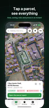
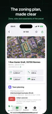
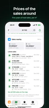
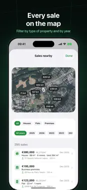
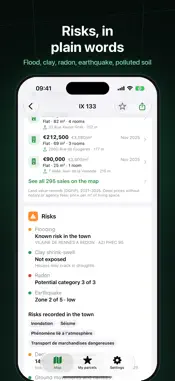
Tap a parcel on the map: ParcelleTool tells you everything public data knows about it. Before buying land, building or extending, gather in an instant what usually takes five different websites. THE PARCEL • Cadastral reference, area, perimeter and address • Aerial photo and IGN map, with parcel outlines and numbers • The buildings standing on it: footprint, height, floors, dwellings, year • Search by address, town or parcel reference ("Rennes IX 133") • A tool to measure an area or a distance on the map TOWN PLANNING (FRANCE) • The plan in force: PLU, PLUi, communal map or national rules • The parcel's zone and what it allows, in plain words, with a link to its rules • Public easements: historic monuments, risk prevention plans… RISKS (FRANCE) • Flood, clay shrink-swell, radon, earthquake • Natural disasters declared in the town • Ground movements, cavities, polluted soil and industrial sites nearby PRICES (FRANCE) • Real sales around the parcel over five years (official land value records) • Median price per m² of houses and flats • Every sale on the map, filtered by type of property and by year ABROAD TOO The land registers of 15 more countries that publish theirs: Spain, Switzerland, Belgium (Flanders), the Netherlands, Luxembourg, Germany (11 states), Poland, Czechia, Slovakia, Slovenia, Estonia, Finland, Norway, Australia and Canada (British Columbia). The parcel, its reference, its area and what the country's register publishes. YOUR PARCELS • Save the parcels you are interested in, with your notes • Export a report as a PDF to send to a notary, a bank or a relative FREE, WITH PREMIUM The essentials are free. Two full reports a day are included, one more per video. ParcelleTool Premium (one-time purchase, no subscription) removes ads and unlocks every report, the PDF report and unlimited saved parcels. GOOD TO KNOW ParcelleTool reads public data (IGN, DGFiP, Géoportail de l'Urbanisme, Géorisques and the other countries' land registers) that may be incomplete or out of date. It has no legal value: only the town-planning certificate, the official risk statement, notarial deeds and a boundary survey count. Available in 14 languages.
What's New
Version 1.1.1 2026-11-07
Find all our available apps in “My other apps”, with their icons and direct links to the App Store. Technical Analysis
Package Overview Basic metadata
Bundle ID
com.Pierre28th.ParcelleTool Current Version 1.1.1
Minimum iOS 17.0
Package Size App Store Size
Package Metadata 0 / 0 version records
Detailed binary, privacy manifest, framework, and Info.plist results have not been indexed for this package yet. The verified App Store and archive metadata above remains available.
Developer Information
Known Version Records
0 version records with stored package metadata
Stored metadata does not guarantee a package is currently available to download.
| Details | Version / IDs | Version date | Action |
|---|