
Preview





Description
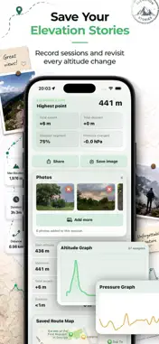
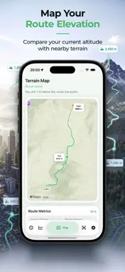
Altimeter AR is a smarter altimeter for iPhone and Apple Watch. It combines GPS altitude, barometer data, pressure trends, route tracking, terrain elevation, and AR-style labels into one clean altitude dashboard. Instead of showing only one number, Altimeter AR helps you understand how reliable your altitude reading is with an Accuracy Engine, sensor details, and clear status explanations. Key features: - Live altitude in meters or feet - Accuracy score based on GPS, barometer, terrain data, and signal stability - Barometer and pressure trend tracking - Route recording with elevation gain, descent, highest and lowest points - Terrain Map with route, altitude markers, and elevation context - Elevation Timeline with interactive altitude and pressure charts - Floor Altimeter for approximate floor climbing and vertical movement - Elevation Lens with AR camera-based terrain labels and heading-aware overlays - Saved sessions with elevation stories, route summaries, charts, maps, and photos - Live Activity for active recording sessions - Apple Watch companion app with altitude, ascent, pressure, route stats, and quick controls - Local history stored on device - Offline-friendly GPS and barometer altitude tracking Altimeter AR is designed for hiking, mountain walks, city climbs, travel, skiing, cycling, and anyone who wants more context than a basic altimeter can provide. Use it to see your current altitude, understand pressure changes, follow your route elevation, compare GPS with terrain data, and review every climb after your session. Pressure trend information is based on sensor changes and should be treated as guidance only. Altimeter AR does not provide an official weather forecast or safety-critical navigation data.
What's New
Version 1.1 2026-08-21
- Elevation Lens now discovers named peaks and terrain up to 25 km away. - AR labels show each point’s distance in kilometers. - Choose up to 40 terrain labels ... Technical Analysis
Package Overview Basic metadata
Bundle ID
com.okroshkalab.peaksense Current Version 1.1
Minimum iOS 17.0
Package Size App Store Size
Package Metadata 0 / 0 version records
Detailed binary, privacy manifest, framework, and Info.plist results have not been indexed for this package yet. The verified App Store and archive metadata above remains available.
Developer Information
Known Version Records
0 version records with stored package metadata
Stored metadata does not guarantee a package is currently available to download.
| Details | Version / IDs | Version date | Action |
|---|