Preview


Description
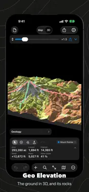
Draw a path and see its elevation profile. Draw an area and see the ground itself: its heights, slopes and contours on the map, and in 3D as a relief you can light, turn and print. Anywhere on Earth, with the numbers a planner needs. The ground in relief. Any area or circle becomes a block of real terrain, shaded as a printed relief map is: a low sun you place, its shadows, and the light of the open sky. Cover it with the map, a tint by height, plain paper or its geology, and let the sunlit slopes glint like a varnished model. The rocks underneath. Choose Geology and the ground takes the colors of the geologic map from Macrostrat, every unit named in the legend, faults drawn, glaciers and lakes marked. Plates to print. Make a plate like a classic survey sheet: the relief from above or as you turned it, sections along your paths, an explanation of the rocks and scales, previewed before you save the PDF. Or save the 3D view as a large picture, a 3D model for AR and Quick Look, a scene for Blender, or an STL file for a 3D printer. On Apple Vision Pro. View as Object sets the block on your table or the floor, to walk around and size with your hands. Stand Here flies it out into the room and opens it into the land at true size, with you standing on the spot you pinched. Walk and turn with the controls, and follow the compass. Ten places to start. Mount Rainier, the Grand Canyon, Yosemite Valley, Zion, Crater Lake and more come with the app and open straight into 3D. Can you see it from here? Draw a straight path between two places and turn on Line of Sight: the ground over the curve of the Earth and the line from your eye to the far end, green while it clears, orange where the ground gets in the way. The view from any point. Draw a circle and turn on View from Center: what its center sees turns green, what the ground hides turns red. Then Look: stand at the center and look around, with the land out to 50 miles. Paths that follow the trail. Add a few points and choose Walking, Cycling or Driving: each leg follows the real path or road. A second later the profile is there, a sample every 30 meters, with distance, climb and descent, average grade and the steepest hundred meters. Areas that answer for the ground. Draw an area, a circle or a rectangle and read the ground inside it: lowest, highest and mean height, relief, mean and steepest slope, and a profile for every path that crosses it. Slope and contours. Color steep ground the way avalanche maps do and draw contour lines spaced for the relief, on the map and in 3D. Layers, as in a drawing app. Many shapes in one document, each in its own color; show, hide and reorder them, and undo every step. Import GPX, KML and GeoJSON; export GPX with elevations, CSV, GeoJSON, a map image or a PDF report. Quick Look shows a document's ground in the Finder and in Files. Free, with Geo Elevation Pro. Everything on the map is free: paths, areas, circles and spots, their profiles and heights, slope and contour layers, line of sight and the view from a point. Geo Elevation Pro, one purchase for iPhone, iPad, Mac and Apple Vision Pro, shared with your family, adds the ground in 3D, Look, Apple Vision Pro and every export. The ten places show their 3D for free. Bought Geo Elevation before it became free? Pro is included. No account, no subscription. Elevation data comes from our own server, ASTER and Mapzen at 30 meters, worldwide; the app needs an internet connection. Kilometers or miles, meters or feet. In English, German, French, Spanish and Japanese.
What's New
Version 3.0 2026-11-03
• Geo Elevation is now free. Geo Elevation Pro, a one-time purchase, adds the ground in 3D and every export. Bought the app before? Pro is included. • The groun... Technical Analysis
Package Overview Basic metadata
Bundle ID
com.objectgraph.geoelevation Current Version 3.0
Minimum iOS 17.6
Package Size App Store Size
Package Metadata 1 / 7 version records
Detailed binary, privacy manifest, framework, and Info.plist results have not been indexed for this package yet. The verified App Store and archive metadata above remains available.
Price History (USA store)
2 recorded price change points. These are historical observations, not a guarantee of the current price.
| Recorded at | Price | Currency |
|---|---|---|
| 1.99 | USD | |
| 4.99 | USD |
Developer Information
Known Version Records
1 version record with stored package metadata • 7 known version records
Stored metadata does not guarantee a package is currently available to download.
| Details | Version / IDs | Version date | Action |
|---|---|---|---|
| 4.32 MB | v1.6 App Store ID: 879595251Build: 1.6 | 2025-11-08 01:35:33 | Get Version |
| Not archived | App Store ID: 879034704 | Unknown | Request Version |
| Not archived | App Store ID: 12911943 | Unknown | Request Version |
| Not archived | App Store ID: 10878318 | Unknown | Request Version |
| Not archived | App Store ID: 8203512 | Unknown | Request Version |
| Not archived | App Store ID: 7438942 | Unknown | Request Version |
| Not archived | App Store ID: 6988559 | Unknown | Request Version |