Preview




Description
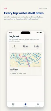
Boat Maps turns your phone into a chartplotter for Amsterdam's canals. It routes you along real waterways — never across a street or a park — so you always know which gracht to take next and where you can tie up when you get there. Built for the sloep you own, and for the one you rented for the afternoon. ROUTING THAT KNOWS YOUR BOAT Enter your boat's height, draught and length once, and every route respects them. Bridges too low for your canopy are routed around. Canals too shallow for your draught are left out. Boats of 10 metres and over are kept out of the grachtengordel, where they are not allowed. BRIDGE CLEARANCES FROM THE OFFICIAL SOURCE Boat Maps carries the published clearance for 432 bridges in and around Amsterdam, 419 of them with an official height, taken straight from Rijkswaterstaat's fairway information service. Every bridge is coloured on the map against your own boat, so one you fit under and one you do not are a glance apart. Arch bridges are listed at their lowest point rather than the crest, because the edge is where you hit. TURN BY TURN, ON THE WATER Directions shaped for a boat rather than a car, with arrival times based on a realistic 6 km/h. Routing runs on your phone, so it keeps working when the signal does not. EVERYTHING ALONG THE WAY Restaurants with their own mooring, jetties, public toilets, drinking water and charging points, all on the map. Every spot carries a chat thread, so skippers can tell each other whether the charger actually works and whether there is room to tie up. A LOGBOOK THAT WRITES ITSELF Trips are recorded while the app is open and stay on your phone. Distance, duration, the track you sailed and the landmarks you passed — kept without you touching anything. UNLOCK MORE, ONCE • Scenic tours with stories: 21 stories along the canals, in Dutch and English. Each one starts by itself as you come near, so you can put your phone down and just steer. Your first 30 minutes are free. • Live vessels on the map: see which canal cruisers, workboats and police boats are moving around you. It earns its keep on the IJ and the Amstel, where the traffic is busy and the big ships have right of way. One-time purchase. No subscription, ever. A word on bridge heights: clearances are published for the kept canal level. Heavy rain can lift the water 10 to 20 cm, arch bridges are lower at the sides than in the middle, and 13 bridges in the area publish no clearance at all. Look up before you go under. Terms of Use (EULA): https://www.apple.com/legal/internet-services/itunes/dev/stdeula/ Privacy policy: https://nickleenders.github.io/boat-maps-privacy-policy/privacy
What's New
Version 1.1.4 2026-09-07
- Plan beyond Amsterdam. Routes now reach Haarlem, Utrecht, the Vecht and the Loosdrechtse Plassen. - Locks on the map. Tap one for today's hours, the chamber a... Technical Analysis
Package Overview Basic metadata
Bundle ID
com.boatmaps.app Current Version 1.1.4
Minimum iOS 15.1
Package Size App Store Size
Package Metadata 1 / 8 version records
Detailed binary, privacy manifest, framework, and Info.plist results have not been indexed for this package yet. The verified App Store and archive metadata above remains available.
Known Version Records
1 version record with stored package metadata • 8 known version records
Stored metadata does not guarantee a package is currently available to download.
| Details | Version / IDs | Version date | Action |
|---|---|---|---|
| 47.61 MB | v1.1.4 App Store ID: 887762436Build: 1.1.4 | 2026-09-07 20:22:04 | Get Version |
| Not archived | App Store ID: 886401567 | Unknown | Request Version |
| Not archived | App Store ID: 886051981 | Unknown | Request Version |
| Not archived | App Store ID: 886009644 | Unknown | Request Version |
| Not archived | App Store ID: 885538855 | Unknown | Request Version |
| Not archived | App Store ID: 885259645 | Unknown | Request Version |
| Not archived | App Store ID: 885064670 | Unknown | Request Version |
| Not archived | App Store ID: 884804932 | Unknown | Request Version |