Preview







Description
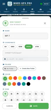
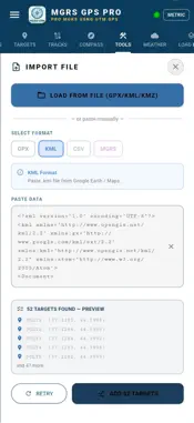
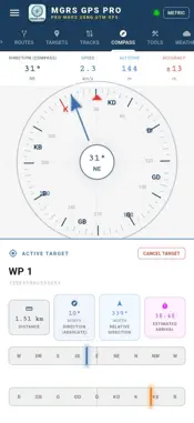
MGRS & UTM GPS Maps PRO is a professional navigation and field-management solution that brings coordinate-grade precision to real-world conditions. From military personnel and mapping engineers to search-and-rescue teams and off-road drivers, it is trusted on any mission where location matters. No internet connection, account, or cloud sign-in is required — it works the moment you open it, in 32 languages. ▸ COORDINATE & GRID SYSTEMS Read any single point in the system you need and switch between them instantly: - MGRS (Military Grid Reference System), USNG and UTM - QTH and decimal LAT/LON - WGS84 and ED50 datum options - DTG (Date-Time Group) time display (Zulu + local) - MGRS grid lines overlaid on the map - Real-time conversion across all systems ▸ MAPS & OFFLINE USE Download before you head out, use it beyond coverage: - Satellite, hybrid, topographic and road layers (default: high-resolution satellite) - Contour (isohypse) and shaded-relief views - Region-based offline map downloads - Your own maps: MBTiles, GeoTIFF, GeoPDF, GeoPackage - Automatic georeferencing of geospatial PDF/TIFF files - 3D terrain view and elevation profile ▸ TARGETS & LIVE GUIDANCE - Create and manage unlimited waypoints - Enter targets by MGRS coordinate or by tapping the map - Live distance, bearing and ETA to the selected target - Attach photos to points for visual records - Share a target in seconds via deep link ▸ ROUTE PLANNING & TRACK LOGGING - Multi-point route drawing with full editing (move/delete/add) - Fine-tuning of segment waypoints - Active navigation mode with off-route deviation alerts - Uninterrupted background track recording - Speed, distance, elevation and total ascent/descent stats - Reuse a saved track as a route - Precise digital compass and deviation indicator ▸ MEASUREMENT, AREA & ANALYSIS - Draw, edit and calculate areas with polygons (m² / km² / acre / hectare) - Auto-import areas from cadastre-compatible KML - Distance measuring tool - Coordinate converter (LAT/LON ↔ MGRS ↔ UTM) - Elevation and slope analysis - Freehand briefing drawing on the map - Weather information and offline cache management ▸ DATA EXCHANGE - Import/export GPX, KML, KMZ and GeoJSON - Point, LineString, Polygon and MultiGeometry support - Open files directly from messaging, email or your file manager - Smart format detection — files are routed to the right tab automatically - Share routes and tracks as GPX/KML ▸ DATA SECURITY & PRIVACY Your location, targets and routes stay on your device only. No data is ever sent to a server — the foundation of operational security (OPSEC) for sensitive missions. ▸ 32 LANGUAGES Turkish, English, German, French, Spanish, Italian, Dutch, Portuguese, Polish, Norwegian, Bulgarian, Croatian, Lithuanian, Romanian, Slovak, Slovenian, Ukrainian, Chinese, Japanese, Korean, Hindi, Indonesian, Malay, Thai, Filipino, Arabic, Persian, Russian, Azerbaijani, Kazakh, Uzbek and Afrikaans. ▸ WHO IT'S FOR Military and tactical movement · geology and mapping engineering · mineral exploration and drilling · cadastral field verification · search and rescue · mountaineering, hunting and off-road.
What's New
Version 5.0.2.20 2026-07-02
bug fixes Technical Analysis
Package Overview Basic metadata
Bundle ID
com.mgrsgpsmappro.milgps.militarygps Current Version 5.0.2.20
Minimum iOS 13.0
Package Size App Store Size
Package Metadata 1 / 2 version records
Detailed binary, privacy manifest, framework, and Info.plist results have not been indexed for this package yet. The verified App Store and archive metadata above remains available.
Known Version Records
1 version record with stored package metadata • 2 known version records
Stored metadata does not guarantee a package is currently available to download.
| Details | Version / IDs | Version date | Action |
|---|---|---|---|
| 38.49 MB | v5.0.2.20 App Store ID: 887676517Build: 5.0.2.20 | 2026-07-02 20:31:46 | Paid / Arcade |
| Not archived | App Store ID: 886608729 | Unknown | Paid / Arcade |