
Preview



Description
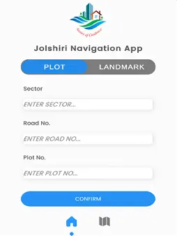
Jolshiri Abashon Navigation is a smart mobile navigation app designed to help users easily locate roads, plots, blocks, and landmarks within the Jolshiri Abashon project in Dhaka. The app combines Augmented Reality (AR) and GPS-based map navigation to provide accurate, real-time directions. On ARCore-supported devices, users can experience immersive on-site navigation with floating directional guidance. For devices without AR support, the app automatically switches to a standard map-based navigation mode. Users can search destinations by entering Road Number, Plot Number, and Block, making it especially useful for officers, buyers, developers, and visitors. The app uses official GIS (shapefile) data of Jolshiri Abashon to ensure precise routing and location accuracy. Key Features: AR navigation using ARCore (supported devices) GPS-based map navigation for non-AR devices Automatic AR & Map mode switching Road, plot, and block-based search Real-time location tracking and routing Clean, minimal, and easy-to-use interface
Technical Analysis
Package Overview Basic metadata
Bundle ID
com.JolshiriAbashon.JolshiriNavigationApp Current Version 1.0
Minimum iOS 13.0
Package Size App Store Size
Package Metadata 0 / 1 version records
Detailed binary, privacy manifest, framework, and Info.plist results have not been indexed for this package yet. The verified App Store and archive metadata above remains available.
Known Version Records
0 version records with stored package metadata • 1 known version records
Stored metadata does not guarantee a package is currently available to download.
| Details | Version / IDs | Version date | Action |
|---|---|---|---|
| Not archived | App Store ID: 881915182 | Unknown | Request Version |