
Preview


Description
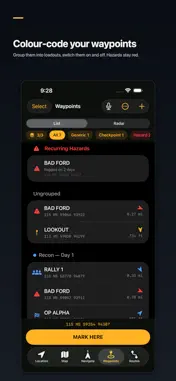
Grid North is offline-first field navigation built around military and survey coordinate systems, not a consumer maps app with a grid bolted on. Made for land navigators, ROTC and cadets, hunters, ranchers, search-and-rescue volunteers, surveyors, hikers and backcountry travelers who need MGRS or UTM and can't count on a signal. TRIP MODE • Start a trip in one tap and watch your trail build live on the map • Sunset countdown that tells you whether you'll get back before dark • "Get me back": an arrow that follows your own trail home • Falling-pressure storm warning from your phone's barometer • Battery forecast and a Save mode that stretches your charge • "I'll be back by" alarm, with a last-known-position screen you can read out over a radio • Finish with a recap of your trail, then share it as a picture RANKS AND BADGES • 20 badges across Easy, Normal, Challenge and Mission tiers • 8 ranks, from Recruit to Legend: finish a tier of badges to move up • All worked out on your phone from your own trips. Nothing is uploaded or compared with anyone. CORE NAVIGATION, NO SIGNAL REQUIRED • Live position in MGRS, USNG, UTM, Lat/Long and OSNG in large, high-contrast type • Five datums: WGS 84, NAD 27, OSGB 36, AGD 66, ED 50 • A live compass dial with an arrow, bearing, distance and terrain-aware ETA to your destination • AR Navigate: point your camera and see your waypoints at their real bearing and distance • Local and Zulu time WAYPOINTS • Mark your position in one tap, type a coordinate in any supported format, project a point by distance and bearing, or say "mark waypoint" hands-free • Loadouts: group waypoints, give each group a colour, and switch groups on and off • Radar view of every waypoint around you • Daylight check: can you reach a waypoint before dark? • Hazard, checkpoint, water, rally, campsite and vehicle categories, with repeat hazards flagged automatically MAPS AND ROUTES • A map with an MGRS/UTM grid overlay, a crosshair for dropping waypoints, and a ruler that snaps to your points • Plan multi-stop routes with cumulative distance and elevation • Terrain-aware route suggestions that favor gentle gradients TRACK RECORDING • Records a breadcrumb trail in the background, even with the screen locked • GPS noise is filtered out, so sitting still stays at zero and distance and climb stay accurate • Replay any trip on the map and get a plain-language summary generated on your device APPLE WATCH • Your MGRS position and a Mark Waypoint button on your wrist • Bearing and distance to your destination • A radar of nearby waypoints, zoomed with the Digital Crown • A watch face complication PRIVACY Your location, waypoints, routes and tracks stay on your device. There is no account, no login, no ads, no analytics and no trackers. Map imagery needs a connection; everything else works offline. LANGUAGES English and Arabic, with full right-to-left layout. One purchase. No subscription.
What's New
Version 1.1.0 2026-09-26
Trip mode is here. • Start a trip: live trail on the map, sunset countdown, climb graph and battery forecast • Get me back: an arrow that follows your own trail... Technical Analysis
Package Overview Basic metadata
Bundle ID
com.blackbridgetec.terratrack Current Version 1.1.0
Minimum iOS 17.0
Package Size App Store Size
Package Metadata 0 / 0 version records
Detailed binary, privacy manifest, framework, and Info.plist results have not been indexed for this package yet. The verified App Store and archive metadata above remains available.
Developer Information
Known Version Records
0 version records with stored package metadata
Stored metadata does not guarantee a package is currently available to download.
| Details | Version / IDs | Version date | Action |
|---|