
Preview




Description
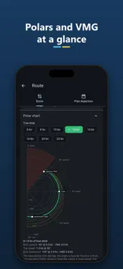
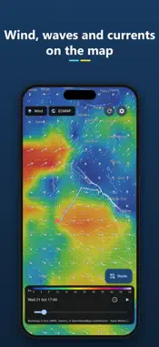
OpenWindRouter is a marine weather and weather routing app for sailors and motorboaters. It shows wind, gusts, waves and currents on the map, compares the main weather models and finds the fastest route with your boat's polar. WEATHER MAP • Wind, gusts, rain, pressure, temperature, clouds, CAPE, waves, swell and currents. • Arrows and animated particles that follow the wind, with a legend and a time slider. • Up to 16 days of forecast, animated hour by hour. • OpenStreetMap, ocean bathymetry, satellite, light or dark basemaps. MODEL COMPARISON Tap any point on the map to compare ECMWF IFS, ECMWF AIFS, NOAA GFS, DWD ICON, Météo-France AROME/ARPEGE, UK Met Office, ItaliaMeteo ICON-2I, Canada GEM and JMA: • wind chart of every model with the mean and the gusts; • hourly table with wind, gust and direction, waves, swell and rain; • charts for waves, current, rain, pressure and temperature. WEATHER ROUTING • Long-press the map to set the departure and the destination. • Isochrone routing that accounts for wind, waves and currents and keeps off the coast (Natural Earth coastline, with an adjustable minimum distance). • Built-in polars for monohulls, a catamaran and a motorsailer, or import your own (.pol, .csv, .txt and ORC tables). • Polar chart with the no-go zone, best upwind and downwind VMG and top speed. • Boat efficiency, engine in light wind, maximum wind and wave limits. • Route and isochrones on the map, boat position at the chosen time, summary with ETA, distance, average speed, max wind and waves, and the share of upwind, reaching and downwind sailing. • Leg table and GPX and CSV export to share with chart plotters and navigation apps. DEPARTURE PLANNING Compute the same route for several departure times, every 1–24 hours, and compare duration, wind, waves and engine hours in a chart and a table: the best window is highlighted. OPEN DATA, NO ACCOUNT • Open-Meteo (CC BY 4.0) and NOAA GFS forecasts, Natural Earth coastline. • No sign-up, no ads, no personal data collected. • Forecasts are kept for a few hours, so data is still there with poor coverage. • Open-source code under the MIT licence. In English and Italian, with light, dark or system theme. Weather forecasts can be wrong. OpenWindRouter helps you plan, but it does not replace nautical charts, official forecasts and the skipper's judgement: do not use it as your only navigation tool.
What's New
Version 1.2 2026-11-04
Bug fix Technical Analysis
Package Overview Basic metadata
Bundle ID
it.openwindrouter.app Current Version 1.2
Minimum iOS 15.0
Package Size App Store Size
Package Metadata 0 / 0 version records
Detailed binary, privacy manifest, framework, and Info.plist results have not been indexed for this package yet. The verified App Store and archive metadata above remains available.
Developer Information
Known Version Records
0 version records with stored package metadata
Stored metadata does not guarantee a package is currently available to download.
| Details | Version / IDs | Version date | Action |
|---|