
Preview





Description
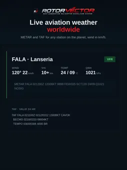
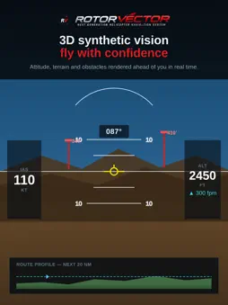
RotorVector is a next-generation Electronic Flight Bag (EFB) built specifically for helicopter pilots. It brings the situational awareness of a modern glass cockpit to your phone or tablet — clean, fast, and designed for how rotorcraft actually fly. FLY WITH FULL AWARENESS • Precision moving map with your aircraft, route and airspace, live on one uncluttered screen • 3D synthetic vision showing attitude, terrain and obstacles rendered ahead of you • Full glass-cockpit instruments — airspeed, altitude, HSI and vertical speed, always in view TERRAIN & OBSTACLES • Vertical terrain profile along your entire route, so you can see high ground before you reach it • Towers, masts and buildings flagged ahead with height and distance • Height–Velocity (dead-man's curve) diagram to help you stay in the safe envelope WEATHER, AIRSPACE & NOTAMS — WORLDWIDE • Live METAR and TAF for stations across the globe, with wind in km/h • Controlled and restricted airspace shown on the map • Active NOTAMs and aeronautical notices along your route PLAN IN SECONDS • Build a route from searchable waypoints and airfields worldwide • Automatic distance, heading, ETA and fuel • Quick briefing and route preview before you launch TRAFFIC AWARENESS • Nearby aircraft shown on your map from open ADS-B/Mode-S data • Tap any target for type, airline, route and a photo BUILT FOR PILOTS • Works around the world — take it wherever you fly • No account and no ads • Community helipad and airstrip database that improves as pilots contribute IMPORTANT SAFETY NOTICE RotorVector is a supplemental situational-awareness aid. It is NOT a certified navigation, weather, or collision-avoidance system and must never be used as a primary means of navigation. Always rely on certified equipment and maintain your own visual lookout. You are responsible for the safe conduct of every flight.
What's New
Version 1.0.1 2026-09-28
VFR Chart basemap — topographic map with airspace, airfields and navaids Live traffic — nearby aircraft via ADS-B, now with balloon/microlight/glider tagging; ...VFR Chart basemap — topographic map with airspace, airfields and navaids Live traffic — nearby aircraft via ADS-B, now with balloon/microlight/glider tagging; tap any aircraft for a flight card (route, progress, ETE & ETA) Obstacle awareness — towers, masts and power lines on the map with proximity alerts SACAA infringement hotspots — known airspace-busting areas with official guidance Rain radar — live precipitation overlay Offline maps — download an area (map, obstacles, airspace & terrain) and fly with no signal 3D terrain view — improved synthetic terrain with clearer relief Redesigned map layout — cleaner data bar (AGL/GS/TRK/DTK), quick rails and next-waypoint strip Added About screen Advisory/supplemental aid only — not a certified navigation instrument. Technical Analysis
Package Overview Basic metadata
Bundle ID
com.rotorvector.rotorvector Current Version 1.0.1
Minimum iOS 15.0
Package Size App Store Size
Package Metadata 0 / 0 version records
Detailed binary, privacy manifest, framework, and Info.plist results have not been indexed for this package yet. The verified App Store and archive metadata above remains available.
Known Version Records
0 version records with stored package metadata
Stored metadata does not guarantee a package is currently available to download.
| Details | Version / IDs | Version date | Action |
|---|