Preview




Description
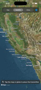
SkyQuant RF plans one-way radio links over real terrain. Tap the map or the 3-D globe to place a transmitter. Set its height (feet above ground or above sea level), the receiver's altitude, the frequency, transmit power (dBm, dBW or watts), antenna gains, receiver sensitivity and the range to sweep. Then compute coverage: the server sweeps all 360° around the transmitter over terrain and paints the result on the map — the covered area as an outline, a heat map of received power (margin above your sensitivity floor, or absolute dBm), and the range ring. LINK BUDGETS • Tap anywhere to budget a link to a receiver at that point. • A plain verdict on the link itself: LINK CLOSES (10 dB or more of margin), MARGINAL LINK (0 to 10 dB) or LINK FAILS — judged on received power against your sensitivity floor, not on line of sight alone. • The received power, the margin and the loss breakdown: free-space path loss, diffraction, ground reflection and whatever the chosen model adds. • A second line about the path: clear line of sight, diffracted over the earth's bulge beyond the radio horizon, or diffracted over terrain in the way. • The link line on the map takes the verdict's colour. Tap again to move the receiver. PATH PROFILE • Terrain with earth curvature applied, the straight line of sight, the first Fresnel zone and its 60 % clearance line, and a marker where the path is first obstructed. • Drag across the chart to read terrain height, line-of-sight altitude, clearance and the Fresnel radius at any distance. PROPAGATION MODELS • Basic — free-space loss, knife-edge diffraction and two-ray ground reflection • Multi-edge diffraction (Deygout) • Longley-Rice ITM • ITU-R P.1812 • Hata and COST-231 Hata, with an urban, suburban, rural or open area type • ITU-R P.530 Polarization, ground type, clutter and rain options apply where the model supports them. Feet in the interface, metres and dBm on the wire. Your last values are remembered between launches, and the coverage colour and heat map are yours to set. PRIVACY • No accounts, no analytics, no advertising, no tracking, no third-party SDKs. The app never asks for your location. Your settings stay on your device. REQUIREMENTS SkyQuant RF is a client: the terrain and propagation calculations run on its operator's SkyQuant server. The address is built into the app, so there is nothing to set up (Settings can point it at a different SkyQuant server). A network connection is required, and the app cannot compute anything while that server is unreachable. Results are planning estimates from terrain data and propagation models, not a guarantee of real-world performance.
Technical Analysis
Package Overview Basic metadata
Bundle ID
com.kyleschaller.skyquantrf Current Version 1.1
Minimum iOS 17.0
Package Size App Store Size
Package Metadata 0 / 0 version records
Detailed binary, privacy manifest, framework, and Info.plist results have not been indexed for this package yet. The verified App Store and archive metadata above remains available.
Known Version Records
0 version records with stored package metadata
Stored metadata does not guarantee a package is currently available to download.
| Details | Version / IDs | Version date | Action |
|---|