
Preview








Description
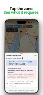
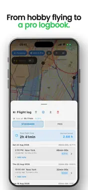
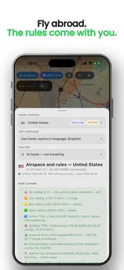
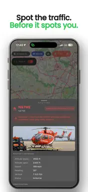
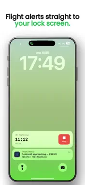
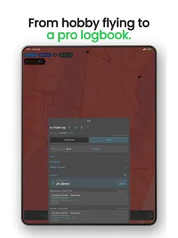
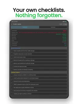
"...truly amazing app. It has almost everything I have been looking for in a single app and now I don't need 4 of the 5 apps I have been using." — Michael, Co-founder SoCal DroneWorks SEE WHAT APPLIES, RIGHT AWAY A clear drone map of the US with FAA airspace information as an overlay — including UAS Facility Map ceilings and active TFRs — plus current temporary restricted areas published via NOTAM. Tap anywhere on the map and get the zone's rules explained in plain language. Airspace and relevant flight restrictions gathered in one clear view. WARNING FOR NEARBY AIR TRAFFIC — EVEN ON THE LOCK SCREEN Get a real-time warning when an aircraft or helicopter broadcasting ADS-B approaches. See distance, altitude and callsign directly on your lock screen. WEATHER FOR DRONES — AT THE RIGHT ALTITUDE Wind at ground level isn't enough. See wind forecasts at 30, 260 and 400 ft, matched to your drone. A clear indicator shows when the forecast for wind or rain crosses your drone's limits. THE RIGHT ND FILTER BEFORE TAKEOFF Filming? The app recommends an ND filter based on sun elevation, cloud cover, current solar radiation for your location, and camera settings such as aperture, frame rate, ISO and shutter angle. Mark which filters you own and the app suggests one of them. You also get the forecast for the hours ahead and when a filter change may be needed. YOUR WHOLE FLEET UNDER CONTROL Dozens of drone models from DJI, Autel, Parrot, Skydio and others are built in, with weight and maximum wind resistance. The app warns you when conditions exceed the limits of the drone you've selected. FLIGHT LOG FOR HOBBY AND WORK Log flights with time, location, drone and weather. Export clear reports as PDF or CSV for your own documentation or business. TAKEOFF-READY IN ONE TAP A pre-flight checklist that automatically checks wind, altitude, position, daylight and NOTAMs. Store your remote pilot certificate and authorizations in the app and keep them available even offline. TRAVELING? THE APP SPEAKS YOUR LANGUAGE Abroad, DroneKoll stays in your language and shows a short briefing for the country you're currently in. Translate official zone text with a single tap and freely choose the language you prefer. The same familiar app in every supported country. NO ACCOUNT. NO ADS. JUST ANSWERS. Start a 7-day free trial and fly smarter today. After that, a subscription is required for continued full access. DroneKoll — built by a pilot, for pilots. NOTE: DroneKoll is a decision-support tool and does not replace official information, required authorizations, or the remote pilot's responsibility. Always check current rules and information with the FAA before flying. Terms of Use: https://www.apple.com/legal/macapps/stdeula/
What's New
Version 1.4.1 2026-10-27
New in 1.4.1 • Improvements and polish. Technical Analysis
Package Overview Basic metadata
Bundle ID
se.dronarkartan.dronarkartan Current Version 1.4.1
Minimum iOS 15.0
Package Size App Store Size
Package Metadata 1 / 17 version records
Detailed binary, privacy manifest, framework, and Info.plist results have not been indexed for this package yet. The verified App Store and archive metadata above remains available.
Developer Information
Known Version Records
1 version record with stored package metadata • 17 known version records
Stored metadata does not guarantee a package is currently available to download.
| Details | Version / IDs | Version date | Action |
|---|---|---|---|
| 102.01 MB | v1.2.9 App Store ID: 887995387Build: 1.2.9 | 2026-08-30 01:54:24 | Get Version |
| Not archived | App Store ID: 887085150 | Unknown | Request Version |
| Not archived | App Store ID: 886847919 | Unknown | Request Version |
| Not archived | App Store ID: 886647920 | Unknown | Request Version |
| Not archived | App Store ID: 886582925 | Unknown | Request Version |
| Not archived | App Store ID: 886512725 | Unknown | Request Version |
| Not archived | App Store ID: 886181550 | Unknown | Request Version |
| Not archived | App Store ID: 885978928 | Unknown | Request Version |
| Not archived | App Store ID: 885759403 | Unknown | Request Version |
| Not archived | App Store ID: 885624058 | Unknown | Request Version |
| Not archived | App Store ID: 885543895 | Unknown | Request Version |
| Not archived | App Store ID: 885448472 | Unknown | Request Version |
| Not archived | App Store ID: 885210799 | Unknown | Request Version |
| Not archived | App Store ID: 885110336 | Unknown | Request Version |
| Not archived | App Store ID: 884863948 | Unknown | Request Version |
| Not archived | App Store ID: 884605806 | Unknown | Request Version |
| Not archived | App Store ID: 883897420 | Unknown | Request Version |