
Preview


Description
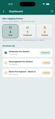
**GeoCollect KFES (Karnataka State Fire and Emergency Services)** is an official, enterprise-grade mobile data collection and field verification application developed by the **Karnataka State Remote Sensing Applications Centre (KSRSAC)** for the **Karnataka State Fire and Emergency Services (KFES)** under the **Home Department, Government of Karnataka**. The application is designed to streamline and digitize field data collection, asset verification, and geospatial surveys for fire and emergency service infrastructure across Karnataka. It enables field personnel to accurately capture the geographic location of assets, collect attribute information, record photographs, and perform on-site verification using GPS-enabled mobile devices. GeoCollect KFES supports real-time and offline data collection, ensuring uninterrupted field operations even in areas with limited or no internet connectivity. Data collected in offline mode is securely synchronized with the central server once network connectivity is restored, improving efficiency and reducing manual effort. The application provides an intuitive and user-friendly interface that enables authorized personnel to: * Capture precise GPS coordinates of fire and emergency service assets. * Collect and update asset-related information through configurable digital forms. * Capture geo-tagged photographs for verification and documentation. * Perform field inspections and validation of existing infrastructure. * Work seamlessly in both online and offline environments. * Synchronize collected data securely with the central GIS database. * Improve the accuracy, transparency, and timeliness of field surveys. GeoCollect KFES leverages modern GIS technology to ensure reliable, standardized, and accurate geospatial data collection. By replacing traditional paper-based surveys with a secure digital workflow, the application enhances operational efficiency, supports informed decision-making, and facilitates effective planning and management of fire and emergency service infrastructure throughout Karnataka.
Technical Analysis
Package Overview Basic metadata
Bundle ID
com.ksrsackgis.kfes-geocollect Current Version 1.0
Minimum iOS 15.0
Package Size App Store Size
Package Metadata 0 / 0 version records
Detailed binary, privacy manifest, framework, and Info.plist results have not been indexed for this package yet. The verified App Store and archive metadata above remains available.
Known Version Records
0 version records with stored package metadata
Stored metadata does not guarantee a package is currently available to download.
| Details | Version / IDs | Version date | Action |
|---|