
Preview







Description
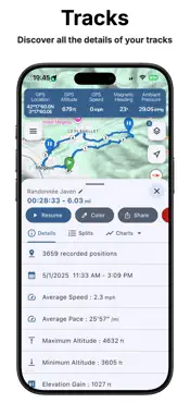
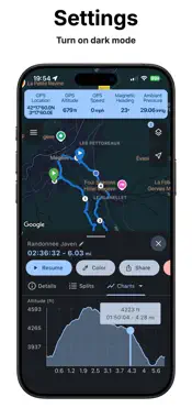
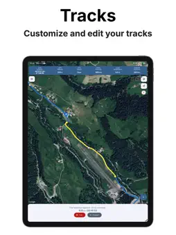
GPS tracking, map measurements and GPS data, all in one app at a very affordable price! Discover MapTools, the evolution of MapPath: an enhanced app with new features, a more modern and intuitive interface, and Google Maps as its map provider for an even better experience. Whether you enjoy hiking, running, skiing, cycling, or simply exploring your surroundings, MapTools is the perfect companion for all your activities. Record your tracks, measure distances and areas directly on the map, and access real-time data from your GPS and your device’s sensors. MapTools is your all-in-one mapping toolkit, right in your pocket! TRACK AND ANALYZE YOUR ACTIVITIES Record your journeys, view your routes on the map, and explore detailed statistics to analyze your activities. - Record tracks in the background, even when your device is locked or you are using other apps. - View your tracks directly on the map. - Check distance, altitude, average speed, elevation gain and loss, kilometer markers, and much more. - Analyze your performance with graphs showing speed, altitude, vertical speed, and weather data over time. - Record multi-stage tracks and resume tracking another day or from a different location. - Follow your position and heading in real time on the map. - Record multiple tracks simultaneously. - Split your tracks to isolate the sections you are interested in. EASILY MEASURE DISTANCES AND AREAS Quickly calculate distances, areas, and circumferences directly on the map using simple and precise tools. - Measure distances by placing successive points on the map. - Calculate the area and perimeter of any region. - Draw measurements directly on the map with your finger or a stylus. - Easily view and manage your measurements on the map. Whether you are planning a hike, measuring a plot of land, or estimating the distance between two locations, MapTools offers a practical and intuitive solution. EXPLORE YOUR GPS AND SENSOR DATA Access a wide range of information from your device in real time. - GPS: geographic coordinates, altitude, speed, heading, and positioning accuracy. - Built-in sensors: atmospheric pressure and magnetic heading, depending on your device’s capabilities. - Weather: access weather data for your current location (Internet connection required). A useful tool for outdoor activities and for exploring and understanding your device’s data. SYNC, IMPORT AND EXPORT YOUR DATA Keep your data organized and easily exchange it with other compatible apps. - Your tracks and measurements are automatically synchronized across your devices via iCloud. - Tag your tracks and measurements to organize them and find them more easily. - Import and export Tracks in GPX or KML format. - Import and export Measurements in KML format. CUSTOMIZE YOUR EXPERIENCE Adapt MapTools to your habits and preferences. - Choose your preferred measurement units. - Select your preferred Google Maps map type. - Enable dark mode and customize the app’s main color. Note: Continuous use of GPS in the background may significantly reduce battery life.
What's New
Version 1.7.2 2026-11-06
Improved import of GPX and KML files Technical Analysis
Package Overview Basic metadata
Bundle ID
fr.julienroze.maptools Current Version 1.7.2
Minimum iOS 17.0
Package Size App Store Size
Package Metadata 1 / 6 version records
Detailed binary, privacy manifest, framework, and Info.plist results have not been indexed for this package yet. The verified App Store and archive metadata above remains available.
Known Version Records
1 version record with stored package metadata • 6 known version records
Stored metadata does not guarantee a package is currently available to download.
| Details | Version / IDs | Version date | Action |
|---|---|---|---|
| 57.61 MB | v1.5.1 App Store ID: 882385280Build: 1.5.1 | 2026-08-10 19:58:52 | Paid / Arcade |
| Not archived | App Store ID: 880967903 | Unknown | Paid / Arcade |
| Not archived | App Store ID: 879643404 | Unknown | Paid / Arcade |
| Not archived | App Store ID: 878540154 | Unknown | Paid / Arcade |
| Not archived | App Store ID: 877883235 | Unknown | Paid / Arcade |
| Not archived | App Store ID: 877628315 | Unknown | Paid / Arcade |