
Preview









Description
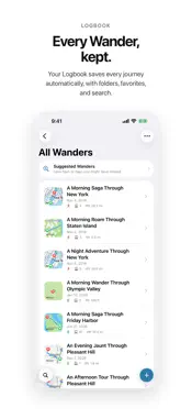
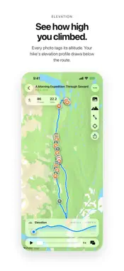
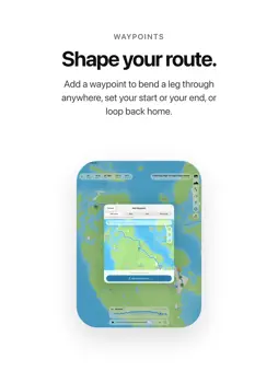
Wander turns the photos from any journey into the route you traveled. Pick the geotagged photos from a stroll, a hike, a bike ride, a road trip, even a flight, and Wander draws the route between every stop in capture order: locked to real streets and trails on land, a clean line across water or sky. Replay it, tap any pin for the photo you took there, and share the result. FEATURES • Photos to route: pick your geotagged photos and Wander builds the path, sorted by capture time and snapped to streets and trails. • Journeys you never saved: Wander can search your photo library for days that look like one and offer them back. It runs on your device and reads only each photo's date and location, never the photos themselves. • The route you actually took: if you recorded a walk, run, ride, or hike in Apple Health while you shot the photos, Wander draws the path it recorded instead of guessing between them. It never writes to Health. • Choose photos your way: filter your library by a day or a date range, jump to a place, or draw a circle on the map to grab everything you shot there. • Every kind of journey: mark any leg as running, cycling, hiking, driving, a train, a boat, or a flight. Wander reads the clues and suggests one. You decide. • Waypoints and Places: shape a route through somewhere you didn't photograph, or set one as your start or end so a train trip draws from the station. Save the spots you use often, like home or a trailhead, and drop one onto any Wander in a tap. • Notes and tags: write a note on a whole Wander, or on any stop, leg, or waypoint, and tag them however you think. Your Logbook searches both. • Weather: look up the conditions and temperature your journey happened in, stop by stop, from the moment each photo was taken. • People: add whoever shared the journey, from Contacts or on the spot. Attach them to a whole Wander or one leg, and browse every journey you've taken together. • Photo pins and replay: every photo becomes a pin you can tap, and pressing play walks a marker along the route with each stop's photo alongside. • Timeline: your journey stop by stop, where you can edit a leg's activity, its people, or a waypoint in place. • Elevation chart: see how high you climbed, read from your photos' GPS altitude and synced to playback. • Insights: lifetime totals across everything you've wandered, from distance and photos to your busiest month. • Logbook: every Wander saves automatically with a fun auto-generated name. Organize with folders, or Smart Folders that fill themselves from rules: runs with Ben but not Sam, anything tagged "coast". • Find it fast: your Wanders turn up in Spotlight search, and "Create a Wander" works from Siri, Shortcuts, or the Action Button. • Built for everyone: Reduce Motion and Transparency, Dynamic Type, higher-contrast pins, and full VoiceOver, including an audio graph of your elevation. • Never lose a Wander: your library backs up to your own iCloud Drive, daily if you like. Deleted ones wait 30 days in Recently Deleted. • On iPhone and iPad: universal, with your Logbook syncing privately across your devices through your own iCloud, not our servers. • Share: send any Wander as a card with the route, the stats, a featured photo, and an optional elevation chart. Frame it with a drag and a pinch; standard or satellite, light or dark, portrait, square or landscape. PRIVATE BY DESIGN • No account, no sign-up. • Your photos never leave your device. Wander reads the ones you choose right where they are and builds the route on device. • No tracking, no ads, no analytics. • What little leaves your device is a coordinate answering something you asked for: Apple Maps for directions and place names, Apple Weather if you look up weather, an elevation service if you look up a height. Never a photo. Wander uses your photos' capture time and location to draw your route. Photos without either are skipped. Go Wander.
What's New
Version 1.9.1 2026-11-10
Wander 1.9.1 is about showing a Wander to someone else: a bigger photo, a sideways phone, and a screen that gets out of the way. NEW • A bigger photo while a r...Wander 1.9.1 is about showing a Wander to someone else: a bigger photo, a sideways phone, and a screen that gets out of the way. NEW • A bigger photo while a route plays. Pinch the photo that appears during playback to resize it, from the size it always was up to the full width of the map. At full width it takes exactly half the screen and the map keeps the other half, so the map never shifts as the photos change. Choose Original under Settings, Playback to keep each photo's own shape. • Turn your phone sideways. Landscape gives the photo one half of the screen and the map the other, for showing a Wander rather than editing one. Drag the photo to whichever side you like and the map swaps with it, and the editing bars stand down until you turn back. This is built for mirroring to a television or a projector, where a portrait phone leaves black bars down both sides. • Tap the map to clear the screen. While a Wander plays, a tap puts the stats, the playback bar and the controls away, leaving the photo and the map. Tap again to bring them back. Nothing moves unless you ask. If the elevation chart is switched on it stays up, sits opposite the photo, and the route is kept clear of it rather than drawn underneath. • The map's controls fold. The column of view controls collapses into a single button, giving the photo the room, and opens again with the same button. • A photo that does not belong. If a photo you picked was taken far enough away that the route has to go out and come back for it, Wander shows it to you before drawing anything and offers to leave it out. You see the photo itself, not just a distance, and with more than one you get a grid and can keep whichever you like. Closing it keeps them all: this is a question, not a correction. IMPROVED • The stats above the map read as a glyph and a value on one line, where each used to be a value over a word. The bar is shorter for it, and a Wander's photo count and distance are now said the same way here as in your Logbook. • The album menu in the photo picker is there the moment the picker opens, instead of arriving a beat later and shifting everything under it. FIXED • The photo above a stop you tap is back to one size, since tapping it opens the photo full screen anyway. The size setting belongs to the playback photo now, and it has moved from Map to Playback in Settings. • The launch screen's icon follows light and dark mode, and no longer draws oversized on an iPad. • In landscape, the route is drawn in the half the map was given, the photo keeps its corner, and pinching it works as it does in portrait. • Clearing the screen gives the photo its full height back instead of leaving it short. Private by design: no account, no ads, no tracking. Your Logbook syncs through your own iCloud, not our servers. Go Wander. Technical Analysis
Package Overview Basic metadata
Bundle ID
com.jmaher.wander Current Version 1.9.1
Minimum iOS 26.0
Package Size App Store Size
Package Metadata 0 / 4 version records
Detailed binary, privacy manifest, framework, and Info.plist results have not been indexed for this package yet. The verified App Store and archive metadata above remains available.
Developer Information
Known Version Records
0 version records with stored package metadata • 4 known version records
Stored metadata does not guarantee a package is currently available to download.
| Details | Version / IDs | Version date | Action |
|---|---|---|---|
| Not archived | App Store ID: 887216727 | Unknown | Request Version |
| Not archived | App Store ID: 886407093 | Unknown | Request Version |
| Not archived | App Store ID: 886302713 | Unknown | Request Version |
| Not archived | App Store ID: 886170835 | Unknown | Request Version |