
Preview




Description
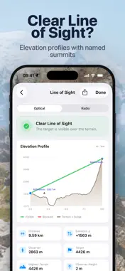
Visible Area: Field of View shows what can and cannot be seen from any location on Earth. Map visibility using real elevation data, check the line of sight between two points and plan the light at any viewpoint. Plan, explore and analyze terrain with clear visual tools, on flat maps or in 3D. KEY FEATURES Viewshed analysis * Generate a visibility map (viewshed) from any location * Set the observer and target height * Free up to 5 km radius * Premium up to 30 km radius Reverse viewshed * Map every place from which a chosen point can be seen * Useful for checking where a summit, tower or building is visible from Line of sight analysis * Check visibility between any two points up to 500 km apart * Identify whether terrain blocks or allows visibility 3D terrain maps * View your viewshed draped over the mountains in 3D * Choose from standard, satellite, hybrid, topographic and custom tile maps Sun and moon planner * See sunrise and sunset times corrected for the real terrain * See sun direction on the map * Premium: any date, golden hour, blue hour and terrain-corrected moon times Radio mode (premium) * Check radio paths with 4/3-Earth refraction and the first Fresnel zone * Use frequency presets from 144 MHz to 5.8 GHz, including ham, LoRa, cellular and Wi-Fi Terrain profiles (premium) * View elevation changes between points * See named peaks along a path * Spot obstructions along the line of sight Search and navigation * Search locations and coordinates * Explore locations worldwide instantly Export and data tools * Save viewshed maps as images * Premium: export viewsheds as KMZ for Google Earth * Premium: export terrain profiles as CSV, GeoJSON, GPX or JPEG PREMIUM FEATURES One-time purchase. No subscription. * Higher resolution 30 m terrain data (limited to North America, EU without Greece and Finland, Japan and New Zealand) * Improved accuracy for visibility analysis * Extended viewshed range up to 30 km * Terrain profile graph * Radio mode with Fresnel zone * Full sun and moon planner * KMZ, GeoJSON, GPX and CSV exports USE CASES * Hiking and outdoor exploration * Landscape photography and viewpoint scouting * Radio and antenna planning * Telecom and network analysis * GIS and mapping projects NOTE Results are based on digital elevation models and may not include buildings, vegetation or temporary obstacles.
What's New
Version 1.2.0 2026-11-07
* 3D terrain: view your viewshed draped over the mountains with Mapbox Outdoors and Satellite maps * Reverse viewshed: map every place from which a point can be... Technical Analysis
Package Overview Basic metadata
Bundle ID
com.ivanblajic.viewshed Current Version 1.2.0
Minimum iOS 17.0
Package Size App Store Size
Package Metadata 1 / 2 version records
Detailed binary, privacy manifest, framework, and Info.plist results have not been indexed for this package yet. The verified App Store and archive metadata above remains available.
Known Version Records
1 version record with stored package metadata • 2 known version records
Stored metadata does not guarantee a package is currently available to download.
| Details | Version / IDs | Version date | Action |
|---|---|---|---|
| 55.66 MB | v1.1.1 App Store ID: 887392742Build: 1.1.1 | 2026-07-27 21:27:03 | Get Version |
| Not archived | App Store ID: 886595174 | Unknown | Request Version |