
Preview





Description
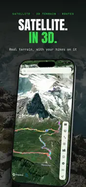
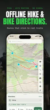
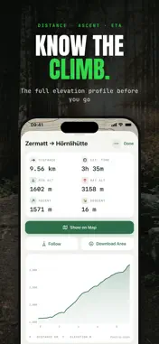
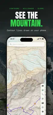
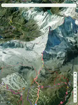
Offline Hiking & Biking Maps is a powerful offline mapping and navigation app for driving, walking, hiking, cycling and more. Plan routes, explore detailed topographic and 3D maps, discover trails, record tracks and navigate without an internet connection. Choose from 15 built-in routing profiles or create your own custom profiles, powered by the BRouter engine. OFFLINE MAPS & ROUTING Download whole regions with map tiles, hillshade, contour lines, trails and routing data for on-device directions. Update downloaded areas in place and see exactly what is taking space. Plan routes along roads, paths and trails, with directions tailored to your activity and routing profile. 3D MAPS WITH MAPBOX Explore Mapbox Outdoors, Standard, Satellite and Streets maps with real 3D terrain. Tilt and rotate the map to see mountains and valleys in relief, with your trails, routes, tracks and waypoints draped over the terrain. TOPOGRAPHIC MAPS Choose from topographic maps built from OpenStreetMap, OpenTopoMap, USGS maps for the United States, Apple Maps and Google Maps. Vector maps get on-device contour lines and hillshading, with contour intervals in meters or feet. Add slope-angle shading to judge steep ground, and overlay ski pistes. TRAILS Every marked hiking, cycling and mountain-bike trail from OpenStreetMap is drawn on the map. Tap one for its length, ascent, elevation profile and difficulty, browse trails near you, and save a trail as a route or download the area around it in one tap. SMART ROUTE PLANNING See your route live on the map as you plan, and save it when it looks right. Colour it by steepness, routing cost, road surface or smoothness so rough or busy stretches stand out, and drop no-go zones to steer it around roads and areas you’d rather avoid. FOLLOW & BACKTRACK Follow a route, trail or recorded track, forwards or back the way you came, with remaining distance, ETA and the next waypoint. Get an alert and a pointer back to the line when you drift off it, even with the phone in your pocket. TRACK RECORDING Record hikes, rides and runs with live distance, moving time, speed and elevation gain. Pause and resume recordings, explore interactive elevation profiles, and keep track of your days out with weekly distance, streaks and a calendar. YOUR MAPS, YOUR WAY Mark waypoints with notes, symbols and colours. Keep your routes, tracks and waypoints in a searchable Library with tags. Import and export GPX, and search for places and addresses. PRIVACY No account or sign-in required, and no ads. Your recorded tracks stay on your device and are never uploaded. PRO FEATURES Recording, topographic maps, trails and route planning are free. A one-time Pro purchase, with no subscription, unlocks offline areas and directions, follow mode with off-track alerts and Backtrack, routes of any length and number, every routing profile including custom ones, no-go zones, Mapbox 3D maps, satellite imagery, slope shading, GPX import and export, unlimited waypoints and stats charts. IMPORTANT Maps, elevation data and routes may be inaccurate or incomplete. Always carry appropriate navigation equipment, check local conditions and use your own judgment. Never rely on the app alone for navigation or safety. Map data © OpenStreetMap contributors. Maps and 3D terrain © Mapbox. Not affiliated with or endorsed by Mapbox, the U.S. Geological Survey or the U.S. government.
What's New
Version 4.2 2026-11-16
- improved user experience Technical Analysis
Package Overview Basic metadata
Bundle ID
com.ivanblajic.TopoMaps Current Version 4.2
Minimum iOS 16.0
Package Size App Store Size
Package Metadata 1 / 1 version records
Detailed binary, privacy manifest, framework, and Info.plist results have not been indexed for this package yet. The verified App Store and archive metadata above remains available.
Price History (USA store)
4 recorded price change points. These are historical observations, not a guarantee of the current price.
| Recorded at | Price | Currency |
|---|---|---|
| 0.99 | USD | |
| 2.99 | USD | |
| 0.0 | USD | |
| 5.99 | USD |
Known Version Records
1 version record with stored package metadata
Stored metadata does not guarantee a package is currently available to download.
| Details | Version / IDs | Version date | Action |
|---|---|---|---|
| 12.95 MB | v2.0 App Store ID: 883546599Build: 2.0 | 2026-08-24 12:30:45 | Get Version |