
Preview


Description
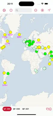
QF Pilot puts worldwide NOTAMs, weather and volcanic-ash advisories on one interactive map — decoded, colour-coded and stored offline for the flight deck. Built for long-haul airline operations, QF Pilot gives you a briefing-room picture of your whole network at a glance: • Interactive world map with colour-coded airport status for more than 600 airports • Full NOTAM listings for every airport in your lists • METAR and TAF weather, decoded into plain language • Volcanic ash advisories from worldwide VAAC centres, plotted on the map • Custom airport lists — build your own, share them with colleagues, and subscribe to lists shared by your fleet • Colour categories you can customise per airline or aircraft type • Offline access — sync before departure and your data flies with you • Optional Dropbox backup for documents and notes • Optional iCloud sync of your settings between devices Data is refreshed continuously on our servers from official government sources: NOTAMs, METAR/TAF weather, and VAAC volcanic advisories. QF Pilot is a situational-awareness and briefing aid. It is not a substitute for official flight briefings or dispatch documentation — always verify operationally significant information through approved channels.
What's New
Version 1.4 2026-09-24
• New: Settings › Appearance. Choose System, Light or Dark; the map switches to a dark basemap and every screen follows. • New: your checklists sync between you... Technical Analysis
Package Overview Basic metadata
Bundle ID
com.interactivewebs.qfpilot.app Current Version 1.4
Minimum iOS 15.0
Package Size App Store Size
Package Metadata 0 / 0 version records
Detailed binary, privacy manifest, framework, and Info.plist results have not been indexed for this package yet. The verified App Store and archive metadata above remains available.
Developer Information
Known Version Records
0 version records with stored package metadata
Stored metadata does not guarantee a package is currently available to download.
| Details | Version / IDs | Version date | Action |
|---|