
KāPix Wyoming
IPA AnalysisPreview




Description
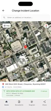
KāPix Wyoming is a field reporting tool for Wyoming public safety officers. It replaces the clipboard at a crash scene: capture the documents, fix the location, draw the diagram, and leave with a complete report ready to share. DOCUMENT CAPTURE Scan driver licenses, vehicle registrations, and proof of insurance with the camera. Details are read from the document and attached to the incident, so information is recorded once at the scene instead of re-keyed back at the station. Scene photographs attach to the same record. AGENCY-CANONICAL LOCATION Incident coordinates resolve to the WYDOT reference through WIGLS: intersection name, route number, milepost, and the distance and direction from that intersection. The location on your report matches the state's linear referencing system rather than a generic street address. When a pin falls away from any indexed route the app says so instead of showing a stale reference, and the lookup can be re-run on demand. SCENE DIAGRAMS Build a diagram on satellite imagery of the actual location. Place and rotate vehicles, add roadway features and annotations, and mark points of impact. An AI-generated blueprint of the intersection provides the base layer, aligned to the real geometry of the scene, so the diagram reflects the road as it is rather than a generic template. REPORTS Produce a PDF containing the captured documents, the location reference, the diagram, and unit details, then share it through the standard iOS share sheet. BUILT FOR THE FIELD Incident details are cached on the device and synchronize when the network returns, so you can keep working through the gaps in coverage that come with rural patrol rather than waiting on a signal. ACCESS KāPix Wyoming requires an account issued to authorized agency personnel. It is not a public-facing service and is not intended for general use. NOT AN EMERGENCY SERVICE This app is used by authorized personnel to document traffic incidents and road accidents. It is not a channel for reporting crimes, emergencies, or incidents in progress. In an emergency, call 911.
What's New
Version 1.3.5 2026-10-12
• Diagram improvements: the trace lines up with the map more precisely, street names can be shown or hidden from the toolbar, and diagrams save reliably whether...• Diagram improvements: the trace lines up with the map more precisely, street names can be shown or hidden from the toolbar, and diagrams save reliably whether or not a vehicle has been placed. • The "Add an object" panel now follows your light/dark appearance setting, and the add button shows a vehicle icon. • Incident locations resolve via WYDOT referencing — intersection, route, and milepost — shown as a green card on the map. • Redesigned document overview: search, category chips, and sort by time, unit, position, or type. • Stability and performance improvements. Technical Analysis
Package Overview Basic metadata
Bundle ID
com.itis.wyoming.kapix Current Version 1.3.5
Minimum iOS 16.0
Package Size App Store Size
Package Metadata 0 / 2 version records
Detailed binary, privacy manifest, framework, and Info.plist results have not been indexed for this package yet. The verified App Store and archive metadata above remains available.
Known Version Records
0 version records with stored package metadata • 2 known version records
Stored metadata does not guarantee a package is currently available to download.
| Details | Version / IDs | Version date | Action |
|---|---|---|---|
| Not archived | App Store ID: 886393225 | Unknown | Request Version |
| Not archived | App Store ID: 874281588 | Unknown | Request Version |