
Preview




Description
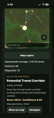
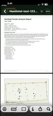
Scout Smarter. Hunt Smarter. Understand Terrain Like Never Before. HuntIntel Terrain Intelligence uses the HuntIntel Terrain Intelligence Engine (HTIE™) to analyze up to 2,000 acres in minutes and identify terrain features that may influence wildlife movement, search and rescue planning, and broader terrain assessments. Instead of spending days walking unfamiliar ground, HTIE evaluates elevation, slope, aspect, terrain position, topographic structure, and spatial relationships to highlight high-value locations that deserve a closer look. Whether you are scouting a new hunting property, preparing for a search and rescue mission, or studying unfamiliar terrain, HuntIntel Terrain Intelligence helps you make better decisions before you ever step into the field. Built for Hunters Every acre matters. HTIE analyzes the landscape to identify terrain features commonly associated with wildlife movement and hunting strategy, including: Saddles Benches Ridges Draws Funnels Pinch points Travel corridors Bedding-area candidates Stand-location candidates Observation points Access routes Terrain relationships Each recommendation includes a detailed explanation of why it was selected, helping you understand the terrain instead of simply placing unexplained pins on a map. Analyze an entire property in minutes from your iPhone, iPad, Mac, PC, or web browser, then head into the field with a plan. HuntIntel Terrain Intelligence Engine (HTIE™) Unlike traditional mapping apps, HTIE performs deterministic terrain analysis using advanced terrain-processing algorithms. The engine evaluates: Elevation Slope Aspect Terrain position Spatial relationships Topographic structure Every recommendation is explainable and based on measurable terrain characteristics. HTIE clearly distinguishes among: Terrain-derived findings Terrain-assisted candidates requiring field verification Field observations that cannot be determined from terrain alone The engine does not fabricate evidence that cannot be supported by the available terrain data. Navigate in the Field Once your analysis is complete, take it into the field. View analysis waypoints on the map Navigate directly to important terrain features Record personal scouting notes Save observations for future trips Keep your terrain intelligence organized Turn digital terrain analysis into practical, real-world scouting. Search and Rescue HTIE can also support search and rescue planning by identifying terrain characteristics that may influence travel, visibility, containment, and search priorities. Examples include: Likely travel corridors Drainages Observation points Potential containment locations Hazard areas Terrain bottlenecks Search-priority areas Terrain analysis is intended to support planning and field awareness. It is not a substitute for trained search and rescue personnel, established procedures, or operational decision-making. Understand Unfamiliar Land HuntIntel Terrain Intelligence can also be used to evaluate: Recreational property Ranches Timberland Conservation areas Survey areas Outdoor recreation sites Quickly understand how unfamiliar terrain is organized before visiting the property. Access your analyses from: iPhone iPad Mac PC Web browser Your analyses remain synchronized, allowing you to start on one device and continue on another. Features AI-assisted terrain analysis HuntIntel Terrain Intelligence Engine (HTIE™) Analysis of up to 2,000 acres Interactive terrain maps Smart waypoint generation Terrain-feature detection Explainable recommendations PDF reports Field navigation Personal notes Offline map support Cross-platform access Deterministic terrain analysis Designed for the Outdoors HuntIntel Terrain Intelligence gives you powerful tools for making informed decisions. Stop guessing. Start understanding your terrain with the HuntIntel Terrain Intelligence Engine (HTIE™).
What's New
Version 1.0.1 2026-11-03
Improved account registration with clearer password requirements, field validation, and error messages. Technical Analysis
Package Overview Basic metadata
Bundle ID
com.huntintel.terrainintelligence Current Version 1.0.1
Minimum iOS 15.1
Package Size App Store Size
Package Metadata 0 / 0 version records
Detailed binary, privacy manifest, framework, and Info.plist results have not been indexed for this package yet. The verified App Store and archive metadata above remains available.
Developer Information
Known Version Records
0 version records with stored package metadata
Stored metadata does not guarantee a package is currently available to download.
| Details | Version / IDs | Version date | Action |
|---|