
Preview

Description
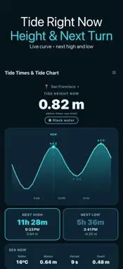
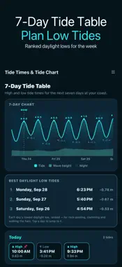
See what the tide is doing right now and for the next seven days: the height this minute, whether it is rising or falling, a countdown to the next high and low, and a clean 7-day tide table you can plan around. Tide Times & Tide Chart is built for anglers, surfers, paddlers, clam diggers, beachcombers and anyone who times a day at the coast around the water. TIDE NOW • Current height above mean sea level, rising / falling / slack • Today's tide curve with a NOW marker • Countdown, time and height of the next high and the next low • Beachcombing window when a low tide in the next 12 hours exposes the shore • Sunrise and sunset SEA NOW • Water temperature, wave height, wave period and swell for the spot you are viewing • °C or °F follows your metres / feet choice SOLUNAR FISHING TIMES • Two major periods (moon overhead and underfoot, about 2 hours each) and the minor periods around moonrise and moonset (about 1 hour) • The period running now, or the next one, is highlighted • Traditional angling guidance from the moon's position, not a promise of bites 7-DAY TIDE TABLE • Every high and low for seven days, grouped by day, with a 7-day chart showing day and night and wave height • Lowest daylight low tides: each day's lowest low that falls in daylight, ranked, so you can pick the day for rock-pooling, clamming or walking the flats • Tap any high or low to pin a reminder before it (up to 8 pins) SPOTS AND ALERTS • Search any coast by name and save up to 10 spots; plan the weekend from home • If a place has no tide data (usually inland), the app shows the nearest port in its list that does, with the distance, and switches to it in one tap • High-tide and low-tide alerts 30, 60 or 120 minutes ahead COAST • Spring / neap indicator from the moon phase, today's tide range and tide coefficient • Metres or feet everywhere; share a tide report as text HOW IT WORKS Tides, waves and water temperature come from the Open-Meteo marine forecast model for the position you choose, up to seven days ahead. No account or sign-up. Without a connection the app shows a clearly marked sample curve, not real tides. A NOTE ON ACCURACY Heights and times are model estimates above mean sea level, not readings from a local harbour gauge and not chart datum. Exact highs and lows can differ at your beach, in coves and in estuaries. This app is a planning aid and is not for navigation.
What's New
Version 1.0.19 2026-11-03
• On the very first launch after installing, Tide Times & Tide Chart now gets its opening screen ready without first waiting for online settings to download, so... Technical Analysis
Package Overview Basic metadata
Bundle ID
com.moon.tidetimes Current Version 1.0.19
Minimum iOS 16.4
Package Size App Store Size
Package Metadata 0 / 0 version records
Detailed binary, privacy manifest, framework, and Info.plist results have not been indexed for this package yet. The verified App Store and archive metadata above remains available.
Developer Information
Known Version Records
0 version records with stored package metadata
Stored metadata does not guarantee a package is currently available to download.
| Details | Version / IDs | Version date | Action |
|---|