
Preview





Description
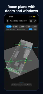
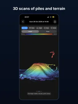
Measure it. Scan it. Set it out. Lidarium turns an iPhone or iPad Pro with LiDAR into a tape measure, a 3D scanner and a "local rover" for stake-out – no GNSS receiver, no coordinates, no account. QUICK AR MEASURE • Distance chains, areas (surface, plan, perimeter), heights from the floor, circles and diameters. • Points snap to wall/floor seams and corners; press and hold for a magnifier loupe. • Mark sockets, switches, lights and pipes, save as a project and continue in AR later. • Screenshot or PDF report in a few taps. ROOMS • Walls, doors and windows with sizes (RoomPlan). Check and correct every frame in AR. • Scan several rooms in a row and get floor plans as PDF and DXF, with wall elevations. DOORS, WINDOWS, STAIRS • Focused element scans: opening width × height, sill and reveal depth. • Stairs as a clean step model: rise, going, width and pitch for every step. 3D SCANS • Objects and terrain – piles, pits, machines – as LiDAR meshes coloured by height. • Furniture: dense points with the floor removed, W × D × H in one walk-around. • Small objects: photo capture builds a detailed textured model on the device. • Site / exterior: house walls, terrace and steps as clean planes, ground with contours. ANALYSE • Ruler with slope, angle, area, circle, pipe/column, volume and clip box. • Flatness heat map for walls, floors and ceilings. • Cut/fill between two scans of the same place. • Remove an object from a scan and close the hole. • Materials: paint, flooring, skirting and earthworks with waste and truckloads. • Object markers with takeoff counts and pipe lengths. STAKE OUT FROM REAL EDGES • Pin line A on a real edge – a curb, a wall, a terrace board – and line B on another. • Templates: rectangle by offsets (slab, pool, foundation), point from a line (post, hole), divide a line, or an outline by sides and angles. • Follow the arrows ("↑ 1.20 m · → 0.35 m") until the target turns green, then mark it. • Averaged pins, control points against AR drift and a live accuracy estimate. • Compare designed and marked sides and diagonals. EXCAVATION • Push a layout down to a flat bottom with working space and side slopes. • Excavation and loose volume, fill, bottom area and depths – see the pit in 3D "as dug" and draw a section. REPORTS AND EXPORT • PDF reports with snapshots and tables, DXF plans, CSV, PLY/OBJ/USDZ models – shared only when you choose to. PRIVATE BY DESIGN • Everything runs on the device. No account, no ads, no tracking, works offline. Requirements: iPhone 12 Pro or later Pro model, or iPad Pro (2020 or later), with LiDAR; iOS 17 or later. Metric and imperial units. English, Swedish and Russian. Measurements are approximate and not survey-grade: LiDAR is about ±1–2 cm at short range; stake-out about 1–2 cm within 5–6 m of the reference lines, and AR drift can add more over longer distances. Check important dimensions with a tape.
What's New
Version 1.8 2026-11-06
New: Height Marker Set a height with your iPhone and find the same height anywhere nearby — like a laser receiver in your pocket. Big ± reading, colours and bee... Technical Analysis
Package Overview Basic metadata
Bundle ID
se.medverk.lidarscan Current Version 1.8
Minimum iOS 17.0
Package Size App Store Size
Package Metadata 0 / 0 version records
Detailed binary, privacy manifest, framework, and Info.plist results have not been indexed for this package yet. The verified App Store and archive metadata above remains available.
Known Version Records
0 version records with stored package metadata
Stored metadata does not guarantee a package is currently available to download.
| Details | Version / IDs | Version date | Action |
|---|