
Preview






Description
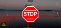
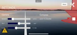
This app alerts you 30 seconds before you enter over the sea chart's 3-meter curve. It also functions in background in the pocket or in a strap on the arm. When the app is on, the camera image is used to display areas in the chart's 3-meter curve with transparent red polygons. The 3-meter curve is provided by the Mapping Division of the sea and refers to depths in relation to the 0-level for depths in charts (sea charts). The app is intended to be used on phones and tablets with forward facing cameras. Attached to the window and directed forward, the app displays camera images with stored NoGo areas (areas of depth less than 3 meters at low tide) in transparent red. A "course vector" points in front of the boat in the course direction. The length of the vector is configurable, in the default option it is set in 30 seconds. The phone can also be held by hand to view the No-Go areas surrounding the boat. The quality of the phone's compass then determines how accurate the display will be.
What's New
Version 1.0.5 2021-01-16
New map over Vestfold. Version 1.0 2020-09-10
Technical Analysis
Package Overview Basic metadata
Bundle ID
geomatics.grunnvarsel Current Version 1.0.5
Minimum iOS 11.0
Package Size App Store Size
Package Metadata 2 / 2 version records
Detailed binary, privacy manifest, framework, and Info.plist results have not been indexed for this package yet. The verified App Store and archive metadata above remains available.
Related Apps


Developer Information
Known Version Records
2 version records with stored package metadata
Stored metadata does not guarantee a package is currently available to download.
| Details | Version / IDs | Version date | Action |
|---|---|---|---|
 77.06 MB | v1.0.50 App Store ID: 840059878Build: 11 | 2020-10-30 12:29:34 | Get Version |
 75.99 MB | v1.0.46 App Store ID: 830855883Build: 5 | 2020-09-10 06:30:26 | Get Version |