Preview


Description
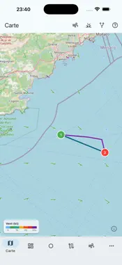
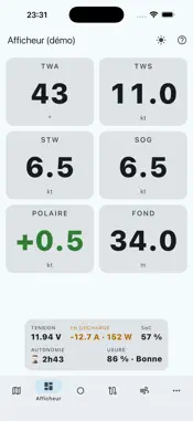
TideRoute Sailing plans and runs your passages, under sail or under power: routing, multi-model GRIB, current and tide, ORC polars, marine charts. Free to start. US NOAA CHARTS Free interactive nautical charts from the Great Lakes to Florida: tap a light to see its details. The Gulf Stream is in the routing, with a wind-against-current alert. THE ROUTING, AND WHY IT IS FASTER Draw your route, pick a departure time, run the calculation. The isochrone algorithm looks for the fastest track from your polar, the wind, the swell, the current, the day/night cycle and your motoring rules, while clearing the coast. Measured on Groix-Ouessant, same GRIB and same polar, 100 % sailing: 16 h 57 for 100 miles, against 20 h 40 for 152 miles on a well-established consumer router. Three hours forty less, 18 %. The gap comes from the algorithm, not from the engine. AND FOR MOTORBOATS Raise the "Motor below" setting above any speed under sail and enter your motoring speed: the routing becomes a power calculation, current, tide, swell and coastline included. Against a 5-knot tidal race, an 8-knot motor cruiser stakes its day on the time of passage. THE CURRENT IS PART OF THE CALCULATION Current is not a decorative overlay: it enters the routing. Useful wind is taken in the water frame, and speed over ground follows. • From the Baltic to the Mediterranean, 412 current areas of at least 1 knot, surveyed over a full spring cycle • Fine mesh where current makes the day: our own 100 m model on the English coast, Ifremer 250 m in Brittany and the Channel, BSH on the Elbe and the Belts, Copernicus Marine elsewhere • Tide computed on board: heights, high and low waters, at any date, with no network • Best departure time: a sweep compares the departures in your window and keeps the one that passes the races at the right moment WEATHER AND MODELS • ECMWF and GFS offshore, up to 10 and 16 days • AROME 1.3 km and ARPEGE 0.1° (Meteo-France), ICON-EU 7 km and ICON-D2 2.2 km (DWD) • The finest model for the area is offered; the GRIB follows the extent of your route THE SOLENT, MODELLED FOR ITSELF General-purpose current sources work on a 1.5 km grid — three cells across a channel three miles wide. We built our own: a hydrodynamic model of the Solent, the Isle of Wight, Hurst and the Needles on a 100 m mesh. Developed with AI assistance, from open data, checked against published tide gauge records. Harmonic tide: currents for any date, months ahead. YOUR POLAR, MEASURED UNDER WAY Start from the monohull and multihull library, from the ORC database — thousands of certified boats — or from your own CSV and .pol files. Then build your own at sea. The capture workshop (experimental) fills an angle / wind-speed grid cell by cell as you sail: it waits for a settled regime, discards the minutes after a manoeuvre, flags doubtful cells. Interpolate the gaps, correct by hand, merge outings, export to .pol or .csv. That is your boat, not the sister-ship's. The display then puts your speed against the target: 96 % upwind, you are still looking; 103 %, you are holding the right trim. ON BOARD • Instrument display (NMEA 0183, Signal K) • Alarms: anchor drag, shallow water, strong wind, cross-track error, battery • AIS, tracks, passage table, GPX export • OpenStreetMap and OpenSeaMap charts: marks, soundings, seagrass • Offline: cached charts, GRIB kept on board, tide computed without network • Comparator: overlay several routings and replay them GFS wind routing is free, without limit. Auto-renewing subscription: it renews unless cancelled at least 24 hours before the end of the period, and can be managed in your App Store account settings. Terms of Use (EULA): https://www.apple.com/legal/internet-services/itunes/dev/stdeula/
What's New
Version 1.2.70 2026-10-28
Your settings now survive a restart: routing options (engine, time step, wind limits), the map display, battery and GRIB retention. Technical Analysis
Package Overview Basic metadata
Bundle ID
polar.maker.plus Current Version 1.2.70
Minimum iOS 15.0
Package Size App Store Size
Package Metadata 0 / 0 version records
Detailed binary, privacy manifest, framework, and Info.plist results have not been indexed for this package yet. The verified App Store and archive metadata above remains available.
Developer Information
Known Version Records
0 version records with stored package metadata
Stored metadata does not guarantee a package is currently available to download.
| Details | Version / IDs | Version date | Action |
|---|