Preview




Description
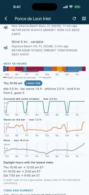
Know what the inlet is doing before you get there. The most dangerous inlet conditions come from an outgoing tide running against waves from the ocean: the ebb shortens and steepens the waves until they stand up and break on the bar. Florida Inlet Watch computes that, hour by hour, for 35 inlets and passes all around Florida — Atlantic coast, Biscayne Bay and the Keys, and the Gulf coast — and puts the official National Weather Service advisories right next to it. Check it before every bar crossing. NEW IN 1.1.1 • Day and night follow the real sunrise and sunset at each inlet: the lowest-index daylight hours never fall in the dark • Daily sun and moon times, with useful moonlight hours • A strip of hourly levels under the inlet map: tap or slide to any hour • Post-Isaias notice on the Panhandle passes: shoals and buoys may have moved FREE FOR EVERYONE Official NWS marine advisories on every inlet (small craft advisory, gale, tropical storm and hurricane warnings) and the NWS coastal waters forecast. TRY PRO FREE FOR 7 DAYS Everything below, free for a week. LIVE — $2.99 A YEAR • Current index for all 35 inlets: Lower risk, Caution, Hazardous or Extreme, with the reasons in plain words • Live NOAA buoys (swell, wind waves, period, direction) and live coastal and airport winds • Today's tides, and today's slack and maximum ebb and flood where NOAA publishes current predictions • Inlet map on the NOAA nautical chart: wind, wave crests and the current through the inlet, right now PRO — $29.99 A YEAR, AFTER THE 7-DAY FREE TRIAL • Everything in Live • Hour-by-hour index for the next 48 hours, every inlet • The inlet map for any hour of the next 48: watch wind, waves and the ebb build up • Ebb current, waves on the bar and wind, hour by hour • Daylight hours with the lowest index • Three days of tide and current times PRO FOR LIFE — $99.99 ONCE: all of Pro, no subscription 35 INLETS AND PASSES Atlantic: St. Marys Entrance, St. Johns River, St. Augustine, Ponce de Leon, Port Canaveral, Sebastian, Fort Pierce, St. Lucie, Jupiter, Lake Worth, Boynton, Boca Raton, Hillsboro, Port Everglades, Bakers Haulover and Government Cut. Biscayne Bay and the Keys: Caesar Creek, Channel Five, Long Key Viaduct, Moser Channel (Seven Mile Bridge), Bahia Honda Channel and Key West Main Ship Channel. Gulf coast: Gordon Pass, Captiva Pass, Boca Grande Pass, Gasparilla Pass, Venice Inlet, New Pass, Longboat Pass, Tampa Bay Entrance, Pass-a-Grille, Johns Pass, St. Andrew Bay Entrance, Destin East Pass and Pensacola Pass. HONEST ABOUT ACCURACY • The app computes how the ebb steepens each offshore wave train (NOAA GFS-Wave) on the bar, then adds wind against the ebb. It never shows a level below an official advisory in effect. • 24 inlets use NOAA's official current predictions. The other eleven have none: the app assumes a wide ebb window and says so. • When a nearby buoy measures bigger waves than forecast, the app raises the forecast, never lowers it. • No "Lower risk" without fresh data: you see "Acquiring data" instead. IMPORTANT Florida Inlet Watch is not a navigation aid. "Lower risk" never means "safe". Sandbars move, sometimes overnight, and models miss squalls. Always look at the inlet yourself, check official forecasts and broadcasts, and make your own decision. Independent app. Not affiliated with or endorsed by NOAA, the National Weather Service or the U.S. Coast Guard. Data: NOAA CO-OPS, NCEP, NWS, NDBC, Aviation Weather Center. Live and Pro renew automatically each year unless cancelled at least 24 hours before the end of the current period (or of the free trial, which then converts to Pro); manage or cancel them in your account settings. Prices are in US dollars for the United States; elsewhere, as shown in the store. Terms of Use: https://gansoft.ch/inletwatch-terms.html Apple standard EULA: https://www.apple.com/legal/internet-services/itunes/dev/stdeula/ Privacy Policy: https://gansoft.ch/inletwatch-privacy-policy.html
What's New
Version 1.1.2 2026-10-23
More accurate danger index: each inlet now uses its real swell window, measured from the bar on NOAA charts. Swell blocked by land no longer counts, swell break... Technical Analysis
Package Overview Basic metadata
Bundle ID
gansoft.florida.inletwatch Current Version 1.1.2
Minimum iOS 15.0
Package Size App Store Size
Package Metadata 0 / 0 version records
Detailed binary, privacy manifest, framework, and Info.plist results have not been indexed for this package yet. The verified App Store and archive metadata above remains available.
Developer Information
Known Version Records
0 version records with stored package metadata
Stored metadata does not guarantee a package is currently available to download.
| Details | Version / IDs | Version date | Action |
|---|