Preview


Description
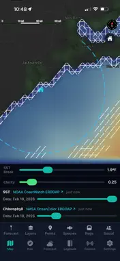
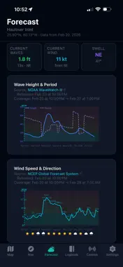
Pelagic Insight puts real-time ocean intelligence in your pocket. Built by fishermen for fishermen, it combines NOAA satellite data, 19,000+ verified waypoints, and detailed inlet information to help you make smarter decisions before you ever leave the dock. OCEAN DATA LAYERS • Sea Surface Temperature with automatic temperature break detection — find where warm and cold water collide • Chlorophyll clarity slider — split clear blue water from productive green water to find bait concentrations • Ocean currents from NOAA satellite altimetry and HF radar • Wind from GFS model and real-time NDBC buoy observations • Wave height and period from WaveWatch III and NDBC buoys • Bathymetry contours — find the shelf edge, canyon heads, and depth changes 19,000+ WAYPOINTS • 6,342 artificial reefs from 14 state fisheries programs • 3,204 shipwrecks from NOAA Electronic Navigational Charts • 8,389 live bottom areas from NOAA Deep Coral database • 505 named natural reefs, ledges, banks, and canyons • Shipwreck histories — tap any wreck to read its story 130+ INLETS — MAINE TO TEXAS • USACE depth soundings for every major inlet on the East Coast and Gulf • Real-time tide predictions and marine forecasts • Flood/ebb tide arrows showing current direction • Per-inlet buoy conditions, wind, and wave data SPECIES INTELLIGENCE • 12 target species with preferred temperature and habitat ranges • Species targeting overlay — see where conditions match your target fish • Seasonal patterns and depth preferences FISHING LOGBOOK • Log your catches with location, species, conditions, and photos • GPS track recording while fishing • Export all your data as a PDF — your logs, conditions, and waypoints SEA CONDITIONS FORECAST • wave, wind, and weather forecasts • Tide curves with sunrise/sunset • NWS marine zone forecasts • Solunar feeding predictions NAVIGATION & COMMS • Compass rose with bearing to waypoints • VHF channel reference with local inlet frequencies • Emergency procedures (MAYDAY, PAN-PAN, SÉCURITÉ) COVERAGE US East Coast and Gulf of America — from Brownsville, TX to Eastport, ME. 18 states, 130+ inlets, and the offshore waters where pelagic species roam. All ocean data sourced directly from NOAA, NDBC, USACE, and NWS. No guesswork — just science. $4.99/month subscription required for full access. Terms of Use (EULA): https://www.apple.com/legal/internet-services/itunes/dev/stdeula/ Privacy Policy: https://pelagicinsight.com/privacy
What's New
Version 1.221 2026-05-13
Added many new sharing features to the application so you can collaborate and share information with others better. Technical Analysis
Package Overview Basic metadata
Bundle ID
com.pelagicinsight.app Current Version 1.221
Minimum iOS 15.1
Package Size App Store Size
Package Metadata 0 / 6 version records
Detailed binary, privacy manifest, framework, and Info.plist results have not been indexed for this package yet. The verified App Store and archive metadata above remains available.
Developer Information
Known Version Records
0 version records with stored package metadata • 6 known version records
Stored metadata does not guarantee a package is currently available to download.
| Details | Version / IDs | Version date | Action |
|---|---|---|---|
| Not archived | App Store ID: 885621447 | Unknown | Request Version |
| Not archived | App Store ID: 884766021 | Unknown | Request Version |
| Not archived | App Store ID: 884114192 | Unknown | Request Version |
| Not archived | App Store ID: 883943847 | Unknown | Request Version |
| Not archived | App Store ID: 883623195 | Unknown | Request Version |
| Not archived | App Store ID: 882603602 | Unknown | Request Version |