Preview






Description
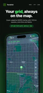
TerraGrid is precision land navigation for soldiers, hunters, search & rescue teams, surveyors and serious outdoors people. Your grid, your compass and your waypoints, working 100% offline. WHAT'S DIFFERENT • Real datum support: WGS84, ETRS89, ED50, NAD27, NAD83, OSGB36, Tokyo, Pulkovo 1942, DHDN, Monte Mario, GGRS87, RT90, KKJ, S-JTSK, HD72, CH1903+ and more — 27 datums that match the paper maps in your pocket. • National grids by name: PUWG 1992/2000, Gauß-Krüger, Gauss-Boaga, TUREF, Lambert 93, SWEREF 99, ETRS-TM35FIN, ΕΓΣΑ87, PT-TM06, Lambert 2008, RD, S-JTSK, EOV, Stereo 70, LV95, HTRS96/TM, D96/TM, TWD97 TM2, VN-2000, RT90, KKJ, NGO 1948 and Japan's plane rectangular systems. • On-device AI field assistant (iOS 26+): "drop a rally point 100 m north of me", fully offline. • Apple Watch, AR finder and Live Activities: your grid on your wrist, waypoints in your camera view, range on your lock screen. COORDINATES & DATUMS — MGRS, UTM, USNG, DD, DDM, DMS, GEOREF and Maidenhead, from 10 km to 1 m precision — Instant converter between every format and datum, with copy and share — Coordinate OCR: point the camera at a paper map or a written grid and import it MAP & POSITION — Zoom-adaptive MGRS grid overlay with 100 km squares, zone boundaries and labels — Big-type Position screen: date-time group (local + Zulu), grid, barometric and GPS altitude (MSL/HAE), accuracy, position averaging with CEP — Offline map regions: download an area once, navigate without signal WAYPOINTS, ROUTES & TRACKS — Tactical waypoints with NATO-style symbols, folders and layers — Routes with leg tables, terrain-aware time estimates, elevation profile and a printable route card PDF — Track recording with pause, Auto-Pause and moving time, elevation profile and backtrack — GPX, KML and CSV import & export; QR hand-off between devices COMPASS & FIELD TOOLS — True, magnetic and grid north compass with offline WMM2025 declination, bearing lock and mils — BMNT/EENT twilight, sun & moon, pace-count dead reckoning — Grid-stamped photos with EXIF — Voice guidance and red/green night mode TEAM & SYSTEM — Serverless team sharing over your own iCloud: live positions and shared waypoints and routes on the map, no accounts, no servers — Siri: "What's my grid?", home and lock screen widgets, Dynamic Island — Apple Watch app with grid, compass and mark-position complications PRIVACY 100% offline. Zero telemetry. Your location is shared only when you turn on team broadcasting, and waypoints or routes only when you share them — always over your own iCloud. One-time purchase. No subscriptions, no ads, no accounts. Terms of Use (EULA): https://www.apple.com/legal/internet-services/itunes/dev/stdeula/ Privacy Policy: https://enfurbay.github.io/terragrid-site/privacy.html
What's New
Version 1.3 2026-10-31
• Waypoints: pin favorites to the top, select several at once, move them to a folder, filter by category, search by name, note or coordinate, and export a whole...• Waypoints: pin favorites to the top, select several at once, move them to a folder, filter by category, search by name, note or coordinate, and export a whole folder. • Proximity Alert: your phone vibrates and notifies you when you come close to a waypoint, even in your pocket. • Mark My Position saves where you are with one tap. • Team: confirm invitations, choose which team receives your position, and see members' iCloud names. • Reinstalling the app? Your settings come back through iCloud. • On iPad, each section keeps your place when you switch. • Copied coordinates stay on this device, and alerts keep coordinates off the lock screen unless you turn them on. • Faster map, lists and compass, and many fixes. • New national grids: RD (Netherlands), S-JTSK (Czechia, Slovakia), EOV (Hungary), Stereo 70 (Romania), LV95/LV03 (Switzerland), HTRS96/TM (Croatia), D96/TM (Slovenia), TWD97 TM2 (Taiwan), VN-2000 (Vietnam), RT90, KKJ and NGO 1948 — 31 grids and 27 datums in all. • Team sharing: send waypoints and routes to your team over iCloud; teammates and shared points appear on the map, and updates arrive instantly. • Pause and resume track recording; optional Auto-Pause shows your moving time. • Barometric altitude: smoother altitude and climb than GPS. • Undo after deleting a waypoint, route, track, report or shape. • Waypoint folders can be renamed and deleted. • 18 new languages: TerraGrid is now available in 30 languages. • Clear messages whenever something can't be saved, imported or exported; very large GPX/KML files import safely. • Text follows your iPhone's text size setting. Technical Analysis
Package Overview Basic metadata
Bundle ID
com.efbapps.terragrid Current Version 1.3
Minimum iOS 17.0
Package Size App Store Size
Package Metadata 0 / 3 version records
Detailed binary, privacy manifest, framework, and Info.plist results have not been indexed for this package yet. The verified App Store and archive metadata above remains available.
Developer Information
Known Version Records
0 version records with stored package metadata • 3 known version records
Stored metadata does not guarantee a package is currently available to download.
| Details | Version / IDs | Version date | Action |
|---|---|---|---|
| Not archived | v1.2 App Store ID: 893151165Build: 1.2 | 2026-10-15 21:04:38 | Paid / Arcade |
| Not archived | v1.1 App Store ID: 892048660Build: 1.1 | 2026-09-27 01:07:50 | Paid / Arcade |
| Not archived | v1.0 App Store ID: 890715586Build: 1.0 | 2026-09-18 06:53:00 | Paid / Arcade |