
Preview



Description
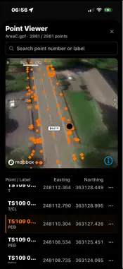
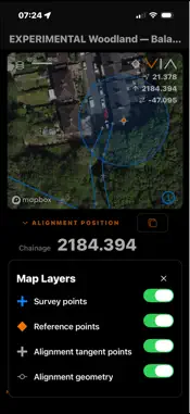
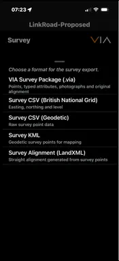
VIA — Field Positioning Navigate. Calculate. Capture. VIA is a mobile field positioning, surveying and GIS data collection application designed for civil engineering, construction, land surveying and geospatial workflows. Combining live GPS positioning, project coordinate systems, engineering alignments and configurable data capture, VIA puts essential spatial information at your fingertips. FIELD POSITIONING & NAVIGATION View your current location in grid or geographic coordinates, or as chainage (station) and offset relative to a selected engineering alignment. Switch between street and satellite mapping to suit your working environment. FIND POINT & STAKEOUT Locate survey points, engineering features and known positions in the field using live GPS navigation. - Import reference coordinates from CSV files, including point numbers, labels and descriptions. - View imported points on an interactive map and browse or search the point list. - Select a target from your reference data or enter coordinates manually. - Navigate towards a target using live distance, bearing and visual map guidance. - Work with grid Easting/Northing or alignment chainage (station) and offset. Ideal for locating survey control, setting-out points, utilities, manholes, inspection chambers, boreholes, trial pits and other mapped assets. VIA brings reference coordinates and live positioning together in a practical field navigation workflow. Positioning accuracy depends on the device and operating conditions. SURVEY & GIS DATA COLLECTION Capture georeferenced observations and point features directly in the field, from individual survey points to structured GIS and site inspection records. - Capture points individually or automatically while moving. - Use configurable templates to record structured attributes and descriptive information. - Add notes to provide context for recorded locations. - Review collected observations and their positions on the map. - Export collected data for further processing in GIS, CAD and surveying applications. Suitable for asset inventories, site inspections, utility records, environmental observations, boreholes, trial pits, marker posts and other geographically referenced information. PHOTOGRAPHIC SURVEYING — VIA PRO Enhance field records with photographs captured using your device camera or selected from your photo library. Associate images with survey observations and use photographic thumbnails in configurable recording templates. Photographic surveying is available through an optional VIA Pro monthly subscription. Core positioning, navigation and non-photographic survey recording remain available without a subscription. ENGINEERING ALIGNMENTS & CALCULATIONS Import and work with engineering alignments using LandXML. - Display chainage (station) and offset relative to an alignment. - Convert between grid coordinates and alignment positions. - Work with straight, circular and transition curve geometry. - Create alignments from recorded positions. - Export alignments for use in other engineering applications. DATA EXPORT & INTEROPERABILITY Move captured information into your existing workflows using standard and portable formats, including CSV, KML, LandXML and VIA project files. VIA works alongside AXIS — Survey Data Tools for further examination and processing of field data. DESIGNED FOR FIELD USE Configure coordinate display order, alignment terminology, distance formatting and other preferences to suit your working practices. Survey data, alignments and application settings are stored locally on your device. VIA does not require an account or connection to a Code Workshop service. Whether you're navigating to a survey location, calculating an alignment position or collecting GIS information, VIA brings practical geospatial tools together in one mobile application. VIA. Navigate. Calculate. Capture. Terms of Use (EULA): https://www.apple.com/legal/internet-services/itunes/dev/stdeula/
What's New
Version 2.0.0 2026-11-02
VIA 2.0 is a major update to field positioning, surveying and GIS data collection. NEW — FIND POINT & STAKEOUT Import reference coordinates, browse points on a... Technical Analysis
Package Overview Basic metadata
Bundle ID
uk.co.codeworkshop.via Current Version 2.0.0
Minimum iOS 16.4
Package Size App Store Size
Package Metadata 0 / 0 version records
Detailed binary, privacy manifest, framework, and Info.plist results have not been indexed for this package yet. The verified App Store and archive metadata above remains available.
Developer Information
Known Version Records
0 version records with stored package metadata
Stored metadata does not guarantee a package is currently available to download.
| Details | Version / IDs | Version date | Action |
|---|