
Preview


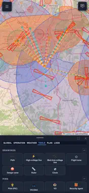


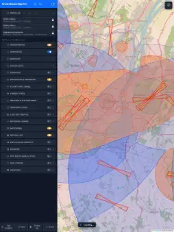


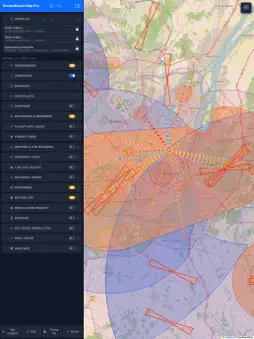
Description
CapDrone is the flight-planning and mission-tracking tool for drone (RPAS) pilots in Canada: airspace, NOTAMs, weather, GO/NO-GO verdict, printable flight plan and report. One map to answer one question: can I fly here, at this hour? AIRSPACE AND AERODROMES • Controlled airspace (surface and 1500 ft AGL), 2 NM buffer, NAV Drone grid • Airports, aerodromes, water aerodromes and heliports: runways, frequencies, CFS • Runway axes with approach and departure corridors; 3 NM and 5 NM buffers • Canadian NOTAMs, readable, drawn on the map and filtered by category • Distances and bearings to aerodromes, parks, correctional facilities and NOTAMs WEATHER AND GO/NO-GO • GO / CAUTION / NO-GO verdict based on YOUR drone's limits: wind, gusts, temperature, visibility, Kp • 7-day forecast with a time slider; decoded METAR and TAF, SIGMET and PIREP • Choice of sources: Open-Meteo, Environment Canada, MET Norway and others • Estimated ceiling, sun, moon, GNSS satellites, radar MISSION: FROM TAKEOFF TO REPORT • New mission with milestone validation: crew, equipment, weather, NOTAMs, airspace • Flights, batteries and flight-time totals per aircraft and per crew member; multi-drone fleet • Safety alerts (aircraft intrusion, weather, zone, runway corridor, battery) and continuous weather readings • Printable end-of-mission report TOOLS AND FLIGHT PLAN • Pins (PIC, VO-DAA, VO, landing, hazards), flight zones and paths with buffer zones, 2 NM, 4 NM and VLOS circles • L1CO validation: coverage, crew reach, distances to aerodromes and airspace • Protected operations (CARs 900.01): 61 m footprint around structures and protected ceiling • Printable flight plan: crew, maps, weather, checklists, appendices • 3D KML export for Google Earth; flight plans saved in the app OPERATOR FILE • Personnel, equipment and company records; documents with expiry dates • Equipment catalogue: 922 standards per published declarations, manufacturer limits • Editable procedure and emergency checklists; client directory FLIGHT LOG • Import DJI (Fly and Pilot 2), Litchi, AirData and GPX logs • Table by year, month and day; track on the map, telemetry, flight weather • Hours per pilot, per drone and per battery; your logs stay on your device HAZARDS AND RESTRICTIONS • Wildfires, correctional facilities, parks, population density, power lines, obstacles, pipelines, RTK stations, live air traffic OFFLINE AND SYNC • Reference data bundled: the app starts without a network • Downloadable area (up to 50 × 50 km) for the offline map • Optional sync between your devices through YOUR OWN FTP server, no account; full backup Interface in French, English and Spanish. Optimized for iPhone and iPad. For recreational and certified pilots (basic and advanced operations), drone service companies, instructors and RPAS students. IMPORTANT NOTICE CapDrone is a planning aid. It does not replace official aeronautical information sources. The pilot remains solely responsible for verifying NOTAMs, weather conditions and applicable regulations with NAV CANADA and Transport Canada before every flight, and for complying with Part IX of the Canadian Aviation Regulations. CapDrone is independent: neither approved nor endorsed by NAV CANADA, Transport Canada or DJI. DJI affiliate links in Settings › Equipment. A DroneTools product, designed by YulDrone in Montréal. https://www.yuldrone.ca
What's New
Version 2.9.3 2026-11-12
• Plan › GO/NO-GO: two-handle flight period (start and end), hour by hour over 72 h, with each hour's verdict. • Flight plan: planned flight height, NAV CANADA ...• Plan › GO/NO-GO: two-handle flight period (start and end), hour by hour over 72 h, with each hour's verdict. • Flight plan: planned flight height, NAV CANADA grid height (m ⇄ ft), mission time zone, and an alert when the height is above the grid height. • KML: flight and grid heights are now taken into account. • Buildings: "Top" and "+ Buffer" (30 m or 100 ft). Technical Analysis
Package Overview Basic metadata
Bundle ID
ca.yuldrone.cartemission Current Version 2.9.3
Minimum iOS 15.0
Package Size App Store Size
Package Metadata 0 / 0 version records
Detailed binary, privacy manifest, framework, and Info.plist results have not been indexed for this package yet. The verified App Store and archive metadata above remains available.
Developer Information
Known Version Records
0 version records with stored package metadata
Stored metadata does not guarantee a package is currently available to download.
| Details | Version / IDs | Version date | Action |
|---|