
Preview




Description
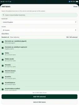
NatureCube Digital Field Assistant is a powerful, offline-first mobile app for researchers, conservationists, ecologists, and citizen scientists to collect, map, and manage biodiversity data in the field. Built by okala, it works seamlessly with the NatureCube web platform so your team can design surveys, analyse results, and report from one connected ecosystem. Whether you’re running a solo monitoring project or coordinating a large field team, NatureCube helps you capture high-quality, standardised data, then sync it to the cloud when you’re back online. Built for the field Collect data with no signal. Record observations as points, lines, or polygons: tap on the map, draw shapes, or walk GPS traces along transects and perimeters. Capture photos, video, audio, numbers, text, and multiple-choice answers in a single field visit, with species picked from your project’s label list. Flexible surveys and systems Design field workflows that match your methods: Survey Builder: create custom surveys on your phone Catalogue and template library: start from ready-made forms Systems and surveys: organise tools and questionnaires for different survey types Project labels: scope species from the global taxonomy to your study area Enterprise-ready field operations Organisations on a NatureCube enterprise plan unlock advanced tools for coordinated field programmes: Sensor deployments: camera traps, bioacoustic recorders, and environmental loggers Sample deployments: soil, water, and specimen collection visits Planned locations: preset sites with guided deployment workflows Overview map: bird’s-eye view of activity across your project Campaigns: time-bounded field efforts with correct attribution Offline maps: download map tiles for remote areas Offline-first, sync when ready NatureCube is designed for remote work. Record observations, deployments, and media on device; review unsynced records on the map or in a table view; upload automatically when connectivity returns. Your data stays safe locally until sync completes. Two ways to get started Individual: sign in with Google or Apple, subscribe in-app, and create your organisation and projects Enterprise: scan your organisation’s activation code from the NatureCube dashboard and join your team’s projects instantly Connected to NatureCube Field data syncs to the NatureCube platform for analysis, visualisation, and team management. On the web, organisations can run AI-powered species identification on audio and video, support camera trap and bioacoustic workflows, and scale reporting across birds, mammals, insects, amphibians, plants, and more. Key features Custom Survey Builder: tailored protocols for any research focus Multimedia capture: photos, audio, video, text, numbers, and geolocation Geospatial mapping: points, lines, polygons, and GPS tracing Offline mode: full field collection without mobile data Background sync: automatic upload when you’re back online Organisations and projects: team structure with map-based project boundaries Species labels: searchable taxonomy scoped to each project Sensor and sample tracking: enterprise deployments with device IDs and photos Planned sites and overview map: coordinate teams across a study area Offline map downloads: enterprise maps for no-signal areas Multi-language: English, French, Spanish, and Indonesian Secure cloud sync: encrypted backups via the NatureCube platform Whether you’re monitoring wildlife in a remote forest, running urban biodiversity surveys, or managing long-term ecological research, NatureCube Digital Field Assistant helps you collect reliable field data and connect it to cutting-edge analysis on NatureCube. Join researchers and conservationists worldwide using NatureCube to advance biodiversity science and environmental stewardship. Terms of Use: https://www.apple.com/legal/internet-services/itunes/dev/stdeula/
What's New
Version 1.0.15 2026-10-26
Added local storage picker and bugfix to handle bad geometry Technical Analysis
Package Overview Basic metadata
Bundle ID
com.okala.digitalfieldassistant Current Version 1.0.15
Minimum iOS 15.1
Package Size App Store Size
Package Metadata 0 / 0 version records
Detailed binary, privacy manifest, framework, and Info.plist results have not been indexed for this package yet. The verified App Store and archive metadata above remains available.
Developer Information
Known Version Records
0 version records with stored package metadata
Stored metadata does not guarantee a package is currently available to download.
| Details | Version / IDs | Version date | Action |
|---|