Preview






Description
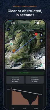
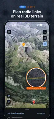
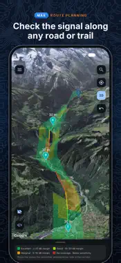
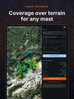
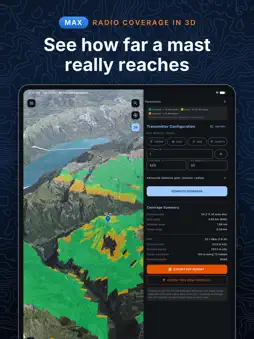
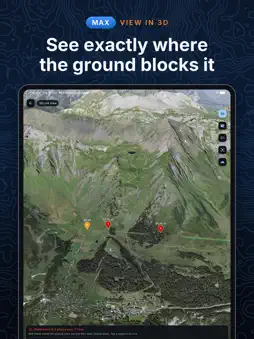
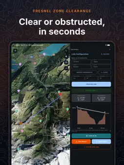
RF Fresnel Calculator tells you whether a radio link will work before anyone climbs a tower. Place two sites, set the frequency and mast heights, and see the terrain between them, the first Fresnel zone and the 60% clearance check, worked out from real elevation data. With Max, the map becomes photorealistic 3D terrain. Your masts, the line of sight, the Fresnel zone and every place the ground cuts into it are drawn right on the hills. FRESNEL ZONE ANALYSIS • Clear or obstructed, judged on 60% of the first Fresnel zone, with 4/3 earth curvature • Terrain profile chart with the line of sight and both masts • Azimuth and elevation from each end • When a link is blocked: how much higher to raise A, B, or both • Frequencies from 30 MHz to 10 GHz, masts up to 1000 m • Set points by tapping the map, typing coordinates or searching for a place 3D MAPS (MAX) • Zoom in and tap 3D: the map rises into photorealistic 3D terrain, on all four map screens • Your link, its Fresnel zone and the 60% zone drawn over the terrain • View in 3D: each obstruction marked, with its distance from A, how far the ground rises into the 60% zone, and its coordinates • Tap the 3D map to place A and B, then analyse the link right there • Coverage, routes and transmitter plans in 3D too RADIO COVERAGE • Place a transmitter and see where its signal reaches over real terrain, shaded Excellent, Good or Marginal • ITU-R P.526 diffraction over terrain, with a correction for surroundings from open ground to city centre • Coverage summary: area covered, best, average and worst range, EIRP TX PLANNER (MAX) • Mark the area you need to serve by tracing, box, circle, typed corners or a KML/KMZ boundary • The planner reads the terrain and ranks transmitter sites inside the area, on its edge or on high ground just outside • Each plan shows how much of the area it covers, and each site what extra mast height would add ADVANCED ROUTE PLANNING (MAX) • Import a route as GPX, KML or KMZ and add up to five transmitters • Signal along the route and a corridor either side, which transmitter serves each stretch, handovers and dead stretches REPORTS AND FILES • HD link report image, saved to Photos or shared • PDF reports for coverage, routes and transmitter plans • KMZ export for Google Earth, including a 3D view of the link • Import KML or KMZ files as map layers, and open GPX, KML and KMZ files from other apps • Satellite, terrain and standard maps, with contour, trail, cycle-route and sea-mark overlays • Portrait and landscape on iPhone, and a side-by-side layout on iPad TERRAIN DATA Heights come from SRTM, GMTED2010, 3DEP and ETOPO1 elevation data through AWS Terrain Tiles, with other elevation services as a fallback. Analyses need an internet connection. PLANS • Free: three link analyses to start, then one short ad per analysis. Coverage scans run after one short ad each. • Pro: no ads, unlimited link analyses and coverage scans. • Max: everything in Pro, plus 3D maps, View in 3D, the Tx Planner and Advanced Route Planning. Pro and Max are auto-renewing subscriptions, billed monthly or yearly. Payment is charged to your Apple Account when you confirm the purchase. Subscriptions renew automatically unless cancelled at least 24 hours before the end of the current period. Manage or cancel them in your Apple Account settings. Terms of Use: https://www.apple.com/legal/internet-services/itunes/dev/stdeula/ Privacy Policy: https://devvratkalia.github.io/privacy_policy_rffresnelcalculator
What's New
Version 3.2.2 2026-10-15
3D MAPS (MAX) • Zoom in and tap 3D: the map rises into photorealistic 3D terrain, on all four map screens • Your link, its Fresnel zone and the 60% zone drawn o...3D MAPS (MAX) • Zoom in and tap 3D: the map rises into photorealistic 3D terrain, on all four map screens • Your link, its Fresnel zone and the 60% zone drawn over the terrain • View in 3D: each obstruction marked, with its distance from A, how far the ground rises into the 60% zone, and its coordinates • Tap the 3D map to place A and B, then analyse the link right there • Coverage, routes and transmitter plans in 3D too Technical Analysis
Package Overview Basic metadata
Bundle ID
com.devvratkalia.rffresnelcalculator Current Version 3.2.2
Minimum iOS 17.0
Package Size App Store Size
Package Metadata 0 / 5 version records
Detailed binary, privacy manifest, framework, and Info.plist results have not been indexed for this package yet. The verified App Store and archive metadata above remains available.
Developer Information
Known Version Records
0 version records with stored package metadata • 5 known version records
Stored metadata does not guarantee a package is currently available to download.
| Details | Version / IDs | Version date | Action |
|---|---|---|---|
| Not archived | App Store ID: 887243755 | Unknown | Request Version |
| Not archived | App Store ID: 886742350 | Unknown | Request Version |
| Not archived | App Store ID: 886302573 | Unknown | Request Version |
| Not archived | App Store ID: 885814212 | Unknown | Request Version |
| Not archived | App Store ID: 885541272 | Unknown | Request Version |