Preview


Description
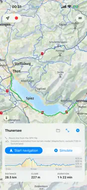
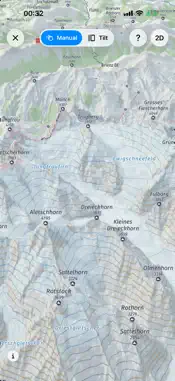
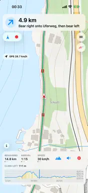
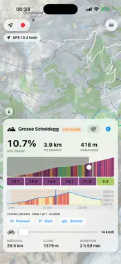
Cycloputer is a cycling map for planning, following and recording bike rides, with its own detailed topographic map. Map coverage The map covers the whole world except Antarctica. It is built from OpenStreetMap and terrain data and hosted by Cycloputer itself. You can save any area for rides without a connection. Lake depths and the offline routing package cover Switzerland. Maps - Detailed topographic map with relief shading, contour lines, cycle and hiking routes and one-way arrows. - Bicycle and Car map types, each in bright and dark. - Overlays for cycle routes, hiking routes, public transport and points of interest. - 3D view of the terrain, controlled by touch or by tilting the phone. - Map legend for every map type. - Offline areas: tap squares on a grid and download them; they work without a connection. Routes - Long-press any place and get up to three route proposals with distance, climb and riding time. - Draw a route between points, drag waypoints, open GPX files, and keep routes and pins in coloured folders. - Elevation profile coloured by gradient, with climbs marked. - Turn-by-turn navigation with voice prompts in English and German, and a Live Activity on the Lock Screen. - Climb view with gradient, distance and height to the summit. - Speed pedelec, bicycle, hiking and car modes, each with its own travel times. All route options are shown together before you start. - Tap a saved route to show it, or drag it onto a folder to move it. - Summit trophies on the elevation profile reopen the figures of a climb. Search - Find places and addresses, or search nearby for categories such as toilets or drinking water. - Tap a station to see its next departures. Recording - Record a ride with live speed and distance. A recording you start continues with the screen off until you stop it. - Optional heart rate, power and cadence sensors (Bluetooth). - Recordings are stored as GPX files on your device and can contain heart rate, power and cadence. You can export GPX or KML and delete routes at any time. The optional account backup encrypts these files before upload; files you export or share yourself contain these metrics. Privacy - No account needed. An optional account backs up routes, pins and folders with end-to-end encryption. No advertising, no tracking. - Your location is requested only when you record, navigate or follow your position. Map data comes from Cycloputer's own server and storage, route directions and place search from Apple (both can be switched off in Settings > General > Apple Maps; routes then use local data and nearby search uses Cycloputer's own map data), and departures from transport.opendata.ch. Each receives only what it needs (see the privacy policy). Important - Routes, directions, elevations and arrival times are estimates. They are not validated for safety or legal access. Check traffic, terrain, weather and closures, obey local rules, and do not operate the app while riding. Use at your own risk; do not rely on it in emergencies. - Cycloputer is not a medical or fitness-measurement product and makes no health claims.
What's New
Version 1.3 2026-11-15
Trophy for every summit. After a climb during navigation, a small trophy appears at the summit on the elevation profile. Tap it to see the climb's figures again...Trophy for every summit. After a climb during navigation, a small trophy appears at the summit on the elevation profile. Tap it to see the climb's figures again. The trophy is kept with the saved route and the recorded ride, so it is there again when you load either later. Show and hide all routes. One entry in the map menu switches between showing all routes and rides and showing none, for example to remove the ride you just finished from the map. A new route or navigation shows them again. Optional Apple Maps services. In Settings › General › Apple Maps, disable the routing fallback and place search independently. With both off, routes use local Valhalla data and nearby search uses our own map data. If local routing fails, the app shows a marked straight-line estimate. Travel mode for simulations. Choose the travel mode through the symbol beside the simulation speed slider. Hiking uses a lower speed range with half-kilometre-per-hour steps. The route line stays unchanged. Changed: Saved routes by tap and drag. Tap a saved route to show it on the map. To move a route into a folder, hold it and drag it onto the folder in the bar that appears at the bottom. Changed: All route options at once. The route options button shows travel mode, road preference and gradient preference together. One tap picks an option, without opening a submenu first. Changed: Dragged route stays magenta. While you drag the route line, the new course is drawn in the route's own magenta instead of green. Changed: Map turns with the follow button. When the map follows your position and direction, it turns to your direction of travel at once, using the compass while you stand still. Switching to another mode turns it back to north. Changed: Clearer route line. The route is drawn in magenta with a white rim and small arrows in the direction of travel, so it stands out from orange and yellow roads. Changed: Elevation profile by swiping. During navigation, swipe the bottom bar up to show the elevation profile and down to hide it. The palette button only switches the grade colours of the route. Changed: Faster speed pedelec routes. For a speed pedelec, the app compares the proposed routes by its own riding time, in which the motor holds the speed on climbs. A shorter route over a hill is now chosen when it is faster, unless you prefer flat routes. The remembered travel mode and gradient preference are shown on the route options button. Fixed: More reliable backup and saved data. Failed backups can be retried, folder and pin changes and local deletions synchronise, and separate folders with the same name stay separate. Incoming routes preserve unrelated files. Unreadable pin and folder files are preserved with an error. Departure groups keep unknown platforms and handle directions around north. About links the online guide and describes worldwide coverage. Offline storage errors are reported. Folder edits ask before discarding changes, and the Go to actions fit compact screens. Missing German account, recovery and error texts are translated. Fixed: Closing a route ends the simulation. Closing the route during a simulation left an empty elevation profile and the simulation controls on the map. Now both close with the route. Fixed: Clearer route buttons and duration. Hiking routes show walking time. The navigation button says Start, and route action buttons keep their labels on one line. Fixed: Departure loading and railway links. Departure loading has a time limit and can be retried after a failure. Railway buttons for Switzerland, Germany, France, Austria, Italy and the Netherlands use bundled country borders and work before departure data arrives. Technical Analysis
Package Overview Basic metadata
Bundle ID
cblum.ch.CyclingMap Current Version 1.3
Minimum iOS 26.0
Package Size App Store Size
Package Metadata 0 / 0 version records
Detailed binary, privacy manifest, framework, and Info.plist results have not been indexed for this package yet. The verified App Store and archive metadata above remains available.
Developer Information
Known Version Records
0 version records with stored package metadata
Stored metadata does not guarantee a package is currently available to download.
| Details | Version / IDs | Version date | Action |
|---|