
Preview




Description
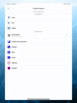
Mobile geospatial tool for superior incident management and collaboration. WES Mobile is a mobile application that uses Open Geospatial Consortium (OGC) and other open standards to provide first responders, surveyors, and in-field data collectors with the ability to collect, consume, share, discover, and access information in connected or disconnected environments. Features: Use WES Mobile on your Apple device to easily search, discover, and access geospatial content and other location-based information through secure wireless communications to the cloud. This app provides superior mapping visualization, fusion, and awareness, including the ability to share, in real time, information and content with other WES Mobile users. Your Apple device now acts as a sensor platform, aggregating data from built-in sensors like GPS, compass, camera, and microphone, and sharing this with other users. Gather and share mobile device information, such as location, photos, video, and other data, in real time. • Annotate and enhance data collected for sharing. • Your device can also connect to external sensor platforms, such as exoskeletons, using either Bluetooth or Wi-Fi. • Discover, manage, and visualize geospatial data and services from disparate sources. • Track and locate other members in your team using WES Mobile. Teams, for example, could include Emergency Response, Police, Firefighters, Family Members, Friends, etc. • Synchronize information and content between team members and see the overall situational awareness picture. • Build a comprehensive map view utilizing many layers from multiple sources. • Measure distances and annotate maps you have created, and share these annotations with other users. • Access a system for organizing information and services relevant to a particular incident, event, or location. • Broadcast messages to other WES Mobile users with the enhanced messaging capability built into WES Mobile. • Enhance location awareness by accessing data, rapidly changing information, and alerts in a real-time environment. • Users can create dynamic forms for data/metadata capture about an incident or event, such as flood mapping.
What's New
Version 1.2 2026-10-12
- Added support for connecting to wireless health devices and data. - Added support for annotating uploading images. - Improvements to map rendering, including ... Technical Analysis
Package Overview Basic metadata
Bundle ID
com.compusult.wesmobile Current Version 1.2
Minimum iOS 16.0
Package Size App Store Size
Package Metadata 0 / 3 version records
Detailed binary, privacy manifest, framework, and Info.plist results have not been indexed for this package yet. The verified App Store and archive metadata above remains available.
Known Version Records
0 version records with stored package metadata • 3 known version records
Stored metadata does not guarantee a package is currently available to download.
| Details | Version / IDs | Version date | Action |
|---|---|---|---|
| Not archived | App Store ID: 888129638 | Unknown | Request Version |
| Not archived | App Store ID: 887904823 | Unknown | Request Version |
| Not archived | App Store ID: 883945659 | Unknown | Request Version |