
Preview


Description
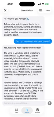
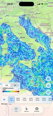
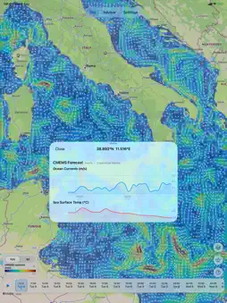
Thalassa turns professional ocean and weather models into a simple map and a friendly advisor for anyone who spends time on the water. REAL-TIME MARINE MAP See the Mediterranean come alive with animated sea-surface currents, wave height, wind, rain, cloud cover, pressure, temperature and water quality. Scrub the timeline — hourly near now, out to +10 days — to watch conditions evolve, tap any point for a detailed meteogram, and switch between layers with a single tap. • Sea-surface currents (animated streamlines) • Wave height, period and direction • Wind, air temperature and mean sea-level pressure • Rain and cloud cover, with sky symbols • Sea temperature and water transparency • Satellite and in-situ observations • Adaptive timeline: hourly near now, out to +10 days SEA ADVISOR — YOUR AI GUIDE Not sure where to go? Just ask. Tell Sea Advisor what you want to do — swim, kayak, surf, snorkel or sail — and it checks the live marine forecast to recommend the best spots and times along the coast, with clear safety notes (waves, wind, UV). OFFLINE READY Download map areas before you leave so you can check your saved conditions even without a signal at sea. TRUSTED DATA Forecasts come from Copernicus Marine (CMEMS), ECMWF and EMODnet — the same operational models used by scientists — delivered by CMCC, the Euro-Mediterranean Center on Climate Change. Thalassa is free, has no ads, and does not track you.
What's New
Version 1.3 2026-09-09
• Mappe più nitide: linea di costa ad alta risoluzione a ogni livello di zoom. Attribuzione OpenStreetMap (ODbL) per i dati della costa. • Palette colore dinami...• Mappe più nitide: linea di costa ad alta risoluzione a ogni livello di zoom. Attribuzione OpenStreetMap (ODbL) per i dati della costa. • Palette colore dinamica: all'apertura di un layer i colori si adattano automaticamente ai dati inquadrati, poi restano stabili mentre cambi data o zoom. Puoi ri-adattarla quando vuoi. • Palette unificata e più leggibile per onde e vento. • Ottimizzazione delle mappe: Livello del mare (SSH) e Temperatura dell'aria, con scale colore dedicate. • Batimetria EMODnet come mappa di profondità dedicata. • Migliore visualizzazione delle previsioni orarie nei meteogrammi. • Correzioni varie e miglioramenti delle prestazioni. Technical Analysis
Package Overview Basic metadata
Bundle ID
it.cmcc.seascapeapp Current Version 1.3
Minimum iOS 17.0
Package Size App Store Size
Package Metadata 0 / 0 version records
Detailed binary, privacy manifest, framework, and Info.plist results have not been indexed for this package yet. The verified App Store and archive metadata above remains available.
Known Version Records
0 version records with stored package metadata
Stored metadata does not guarantee a package is currently available to download.
| Details | Version / IDs | Version date | Action |
|---|