
Preview




Description
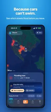
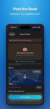
FloodRoute shows which coastal roads will flood at high tide, and when, and lets neighbors post what they're seeing. As featured in The Ark (Tiburon, CA), January 27, 2026. WHAT IT DOES • Street-by-street forecasts: see which roads flood at each high tide, and when the water peaks and drains, 7 days ahead. • Live water levels: forecasts follow the real water, catching surges the tide tables miss. In two years of testing, next-day forecasts landed within 3 inches 80% of the time (tide tables alone: 28%). • Flood photos from neighbors: see what's flooding right now. Tap any photo for the street, the time, who spotted it and the map. • Post in seconds: snap the water and FloodRoute adds the street, the time and the tide height. Faces are blurred automatically. At high tide, one tap tells neighbors "Flooded" or "Looks dry." • Warn your neighbors: share a forecast or a photo to Nextdoor, Instagram or a group text in one tap. Links open a live map in any browser, no app needed. • Alerts: a heads-up before your town floods, a ping when a neighbor posts flooding in your town, and a check-in at the peak. • A map that learns: neighbor reports correct the forecast, so streets seen dry stop showing as flooded. • Call it: guess how high the next big tide will get. NOAA's gauge decides who was closest, and the best callers top a 30-day leaderboard. FREE FOR EVERYONE • The live flood map and 7-day flood windows • Town alerts and neighbor flood pings • Posting and sharing flood photos • No account or login FLOODROUTE PRO • Alerts for your street: the roads around your home, hours ahead • Commute alerts: we check your actual route and tell you when to leave • Surge alerts: when the water runs high, before the tide tables catch on • Up to 3 places: home, work and one more • 30-day flood planner • What-if simulator: see any tide or storm before it happens • A PRO badge on your posts New users get every Pro feature through their town's next big tide. After that, everything free stays free, and Pro is monthly or yearly. WHERE IT WORKS • Marin County, CA: 11 towns, from Sausalito to Novato • San Francisco, CA • Boston, MA • New York City, NY • Miami and Miami Beach, FL • Tampa, FL • In beta: Fort Lauderdale and North Miami, FL; Charleston, SC; Norfolk and Virginia Beach, VA Not on the list? Tap "Map my town" and rally your neighbors. HOW IT WORKS FloodRoute combines NOAA tide predictions and live water levels with high-resolution USGS lidar elevations for every low-lying road. Predictions are calibrated against documented king tides and neighbor reports, and factor in recent rainfall. Every town also has 30 years of flood history at floodroute.com. DATA SOURCES • NOAA CO-OPS: tide predictions and live water levels • USGS 3D Elevation Program: road elevations • OpenStreetMap and Overture Maps: road geometry • FEMA National Flood Hazard Layer: flood zones • Open-Meteo: rainfall and barometric pressure • Neighbor reports and documented king tide flooding: calibration WHY I BUILT IT FloodRoute started with my Nextdoor neighbors in Marin County. I shared the idea and got nearly 200 requests in 24 hours. It's still built by one person, and Pro keeps the free map free. IMPORTANT SAFETY NOTICE FloodRoute provides estimates only and is not a substitute for official warnings. Conditions change quickly. Never drive or walk through flood water: turn around, don't drown. SUBSCRIPTION DETAILS Payment is charged to your Apple ID at confirmation of purchase. Subscriptions renew automatically unless canceled at least 24 hours before the end of the current period. Manage or cancel anytime in your App Store account settings. Support: [email protected] Follow @floodrouteapp on X: https://x.com/floodrouteapp Follow @floodroute on Threads: https://www.threads.com/@floodroute Terms of Service: https://floodroute.com/terms Privacy Policy: https://floodroute.com/privacy
What's New
Version 2.4 2026-10-31
• Call it now has a nationwide leaderboard: see where you stand right on the Call it card, tap to see everyone, and share your rank. • The tide chart now shows ... Technical Analysis
Package Overview Basic metadata
Bundle ID
com.marchoag.floodroute Current Version 2.4
Minimum iOS 18.5
Package Size App Store Size
Package Metadata 0 / 13 version records
Detailed binary, privacy manifest, framework, and Info.plist results have not been indexed for this package yet. The verified App Store and archive metadata above remains available.
Developer Information
Known Version Records
0 version records with stored package metadata • 13 known version records
Stored metadata does not guarantee a package is currently available to download.
| Details | Version / IDs | Version date | Action |
|---|---|---|---|
| Not archived | App Store ID: 884477600 | Unknown | Request Version |
| Not archived | App Store ID: 883563144 | Unknown | Request Version |
| Not archived | App Store ID: 882554543 | Unknown | Request Version |
| Not archived | App Store ID: 882063228 | Unknown | Request Version |
| Not archived | App Store ID: 882023416 | Unknown | Request Version |
| Not archived | App Store ID: 881977781 | Unknown | Request Version |
| Not archived | App Store ID: 881943038 | Unknown | Request Version |
| Not archived | App Store ID: 881866185 | Unknown | Request Version |
| Not archived | App Store ID: 881795966 | Unknown | Request Version |
| Not archived | App Store ID: 881714596 | Unknown | Request Version |
| Not archived | App Store ID: 881681184 | Unknown | Request Version |
| Not archived | App Store ID: 881600092 | Unknown | Request Version |
| Not archived | App Store ID: 881386333 | Unknown | Request Version |