Preview




Description
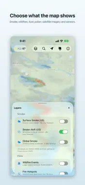
Air Quality shows you what is actually in the air — where the smoke is, where it is heading, and what the air is like at any point on Earth you tap. See the smoke before it arrives A 48-hour NOAA HRRR forecast for the continental US and Alaska, hour by hour, at ground level and through the whole air column. Scrub the timeline and watch a plume move. Outside the US, Copernicus CAMS gives you five days of global smoke, dust, and haze. Air quality across a whole country, not a scatter of dots The US air quality map draws the hourly AQI as a continuous field from EPA AirNow, with a second layer for tomorrow’s forecast. Monitor readings ride on top as pins you can tap. Community sensor readings from OpenAQ cover the rest of the world. A forecast anywhere, not just where a weather station is Tap or press and hold any point on the map for a five-day air quality forecast — a stretch of coastline, a trailhead, a valley with nobody in it. Layers you choose • Ground-level and column smoke, 48 hours (NOAA HRRR) • Global smoke, dust, haze, PM2.5 and volcanic sulphate, 5 days (Copernicus CAMS) • US air quality index, now and tomorrow (EPA AirNow) • EPA monitor readings and worldwide community sensors • Active wildfires and satellite heat detections (NASA EONET, NASA FIRMS) • Daily satellite photography (NASA GIBS) • Volcanoes (Smithsonian Global Volcanism Program) • Pollen forecasts for six species across Europe On every screen you own Widgets and complications for a glance. An Apple Watch app with the reading and a five-day chart. An interactive 3D globe on Apple Vision Pro. An ambient satellite flyover on Apple TV. Multiple windows, a sidebar and a menu bar item on Mac. Free and private No price, no subscriptions, no ads, no accounts. Your location is only used to look up the air where you are, and is never used for tracking. Data from NOAA, Copernicus Atmosphere Monitoring Service, EPA AirNow, NASA, OpenAQ, Open-Meteo and the Smithsonian Institution. Air quality data is provided as published and is not a substitute for official public health guidance.
What's New
Version 2.1.1 2026-11-02
This update makes the map’s data more dependable. • Global Smoke, Dust, Haze and PM2.5 forecasts load reliably, even when the app hasn’t been opened for a while...This update makes the map’s data more dependable. • Global Smoke, Dust, Haze and PM2.5 forecasts load reliably, even when the app hasn’t been opened for a while, and match the time on the timeline. • Air quality, fire and wildfire layers keep refreshing while the app is open, and a layer whose source has fallen behind shows how old its data is. • Satellite imagery is continuous across the Pacific at the date line. • Global forecasts open at the current time, and the timeline stays readable at large text sizes. • Point forecasts are looked up with an approximate location, to about a kilometer. • Other small fixes. Technical Analysis
Package Overview Basic metadata
Bundle ID
com.apparentlogic.Air-Quality Current Version 2.1.1
Minimum iOS 17.0
Package Size App Store Size
Package Metadata 0 / 5 version records
Detailed binary, privacy manifest, framework, and Info.plist results have not been indexed for this package yet. The verified App Store and archive metadata above remains available.
Developer Information
Known Version Records
0 version records with stored package metadata • 5 known version records
Stored metadata does not guarantee a package is currently available to download.
| Details | Version / IDs | Version date | Action |
|---|---|---|---|
| Not archived | App Store ID: 876814780 | Unknown | Request Version |
| Not archived | App Store ID: 868423670 | Unknown | Request Version |
| Not archived | App Store ID: 863323227 | Unknown | Request Version |
| Not archived | App Store ID: 851163289 | Unknown | Request Version |
| Not archived | App Store ID: 824027617 | Unknown | Request Version |