
Preview


Description
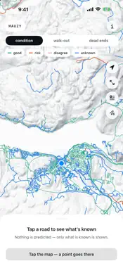
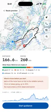
Mauzy covers every Canadian province, Yukon and the Northwest Territories. Outside them it says so and tells you how far the covered area is. It routes and guides you on dirt roads with no network. You pick a region on first launch and it downloads once; after that the phone needs nothing. Large provinces come in parts (Ontario 18, Quebec 17, BC 17, Saskatchewan 7, Alberta 6, Manitoba 4, Yukon 2, NWT 2); you download the one you ride in. What each province gives you is different: Newfoundland and New Brunswick: 86,428 km of forest and resource roads missing from OpenStreetMap entirely. OsmAnd and Organic Maps do not have those roads, because they read only OpenStreetMap. Nova Scotia: the province's network adds gravel tracks OpenStreetMap lacks and marks 19,382 km as dry-weather only. Those show as known risk, as do impassable or abandoned roads and trails closed to vehicles; the rest, unknown. Quebec: the province's register of multi-use roads, about 368,000 km of them not in OpenStreetMap. The province rates each road: passable in two-wheel drive shows as known good, 4x4 only or impassable as known risk. ATV (FQCQ) and snowmobile (FCMQ) trails are drawn dashed, for reference only: Mauzy never routes along them. Ontario: the Ministry of Natural Resources road layer, 196,338 km, about 129,000 km of it not in OpenStreetMap. Gates, berms, destroyed roadbeds, removed crossings, closures and winter roads mark a known risk; open roads with routine maintenance are known good. Alberta: the province's Dry-Weather Road layer, about 108,000 km; what OpenStreetMap lacks is added to the map and to routing. British Columbia: forest roads from the province's forest tenure records. The layer says nothing about surface or condition, so they show as unknown. Roads only applied for are drawn but never routed — they may not exist yet. Yukon: about 8,100 km of cart tracks, exploration and forest roads from the Government of Yukon and the federal topographic base, not in OpenStreetMap. Cart tracks (ATV only) and winter roads are marked as known risk. Saskatchewan, Manitoba, PEI and the NWT: their open road layers add almost nothing to OpenStreetMap, so Mauzy uses OpenStreetMap and terrain alone. Winter and ice roads show as known risk. Mauzy does not promise a road is passable. For every 500-metre piece it shows one of three honest states: known good, known risk, or unknown. Where the data is silent, the app says unknown instead of inventing a score it cannot back up. Off the pavement the useful question is not "will I get through" but "how far do I walk out if I don't". Mauzy answers that before you go: the shortest way to a reliable road, whether a track is a dead end, and how long it runs. - Offline routing and turn-by-turn guidance. No account, no server. - Three map modes: road condition, walk-out distance, dead ends. - Route through up to 10 points. Paste coordinates someone sent. - Load your own GPX tracks: they show on the map and route like roads. - Route profile: climb, descent, and how much of it is steep. - Guidance keeps running with the screen locked. - Nothing about you leaves the phone. No analytics, no tracking. One region is active at a time. The others stay a download away. Data: OpenStreetMap (ODbL); NL Resource Roads (OGL – Newfoundland and Labrador); Nova Scotia Road Network (Nova Scotia Open Government Licence); New Brunswick Forest Roads (New Brunswick Open Government Licence); Quebec RQTT, MRNF, with trails by FQCQ and FCMQ (CC BY 4.0); Ontario MNR Road Segments (OGL – Ontario); Alberta Access and Facility Roads (OGL – Alberta); BC Forest Tenure Road Segment Lines (OGL – British Columbia); Yukon Forest Resource Roads and Vegetation Inventory Roads (OGL – Yukon); NRCan National Topographic Data Base and Canadian Wetland Inventory (OGL – Canada); Copernicus DEM GLO-30 (© DLR e.V. 2010–2014, ESA). Full attribution is in the app. Leaving the pavement is your call. Check the road with your own eyes.
What's New
Version 1.0.3 2026-11-14
Mauzy now works with CarPlay. The car display shows the same road-condition map, the route or stops you planned on your phone, your own GPX tracks, turn-by-turn...Mauzy now works with CarPlay. The car display shows the same road-condition map, the route or stops you planned on your phone, your own GPX tracks, turn-by-turn guidance with alerts, and a Dashboard view next to your music. Guidance started on the phone carries on in the car. Decimal numbers now follow your phone's region format. Technical Analysis
Package Overview Basic metadata
Bundle ID
com.antonstilet.mauzy Current Version 1.0.3
Minimum iOS 18.0
Package Size App Store Size
Package Metadata 0 / 0 version records
Detailed binary, privacy manifest, framework, and Info.plist results have not been indexed for this package yet. The verified App Store and archive metadata above remains available.
Known Version Records
0 version records with stored package metadata
Stored metadata does not guarantee a package is currently available to download.
| Details | Version / IDs | Version date | Action |
|---|